
last edits Aug 21
Why it's a Tree Farm
Of major importance to the investigation of the Qawalish tree farm massacre, of 30-34 civilians allegedly killed by government forces and dumped "in the Qala'a area" is precisely where the mass grave was discovered. The spot is possibly not far from where government soldiers were dumped and found, in a water basin, in July. This is generally presumed a rebel crime, despite the thin excuse that Gaddafi did it.
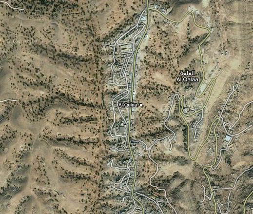
To establish the location of this other, nearby, crime, one must first accept the general locale given. This is the area around Qala'a, by Yefren, about 12 miles northeast of Qawalish, in a small nook of the Nafusah mountains (maps below).

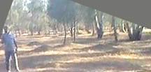
As we can see here, tall evergreens (cedar?) proliferate in all views. Hundreds of them are visible from this one spot. (To actually get a good look, open it full-size in a new window.)
First, it became clear this wasn't the immediate Qala'a area. Aside from the moderate slope to the west and northwest, the ground is too level. There are also too much foliage in too many directions to be the minor forested area that separates Qala'a from Yefren with only thin ribbons of trees along ridge crests. (see the area here)
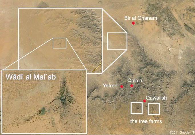
There are however at least two tree farms that have come to my attention as possible locales, thanks to some research by reader Peet73, and a third location that's not a match, thanks to a Libyan rebel group. These are variously given as farm, forest, and agriculture center. The satellite imagery shows the two that matter to be covered with neat rows of irrigated and managed trees suggesting a farm, answering all descriptions fairly enough.
The different locations and names of locations that have been offered for this site have helped us start to identify it, but have also helped confuse things along the way. All three given names are similar enough I was at one point willing to call them all variants of the same. But on examination, they seem to refer to three distinct forested spots. One is irrelevant. The other two both could be a match. One of these reportedly housed government forces and weapons back in May and June at least - and thus perhaps their alleged victims as well.
The Outlier: Al-Ma'lab
Four days after the tree farm massacre surfaced in video form, the group Shabbab Libya issued an August 9 demand for the government (in Benghazi) to open an investigation into this government (in Tripoli) crime. This press release cites the locations as, possibly, "the Al-Mal'ab forest area." It was urgent the bodies be found and given a proper burial as soon as possible, but it'd be slow going, since "this location is heavily mined and it is impossible to search." They also called for mine-clearing teams to get to the area quickly.
This name, al-Mal'ab, is just different enough from the other two, nearly identical-sounding ones, that I had to double-check it. There was no record at Google maps, but a listed "Wādī al Mal`ab in Yafran," at worldgeographics.com, had a roads-based map and a pin locator for it. It was near enough to matter. So I sought the same spot on Google maps, looking for a tree-lined river bed (a wadi is a dry river bed that flows only seasonally).
But what's there is only a tiny, tiny stretch of river valley at the sometimes-river's ben. There are only a few dozen trees, perhaps, visible from any one spot. Whatever the species, that's not enough foliage to explain what the video shows. Shabbab Libya was wrong, but hopefully the NTC can send a team to al-Mal'ab to investigate, and they can step on some mines. Meantime, I just investigate with what I have here.
The Big Farm: Alumblyab

This clue was spotted, and the spot located, by Peet73 on Wikimapia, which has a mile-wide, circular patch of trees in the desert well south of Qala'a, conveniently spelled out as the "Alumblyab forest." This is pictured at right; seen zoomed in, it is a nice match for the scene's gently rolling topography, tree cover, and unusual packed and scored soil.
This gives us a location nearer to Qawalish - the town just outside of which the water basin discovery was made - than to Qala'a. Also known as al-Galaa, the town this video is attached to is Algelawy2009's hometown, he says. "I am from Algalah and I know this area very well," he says in a separate comment at someone else's posting. And he's sure this is at the Alumblyab tree farm. In the area he knows the best, it's right by the town not recently associated with barbaric rebel atrocities.
The One of Previous Interest: Almliab
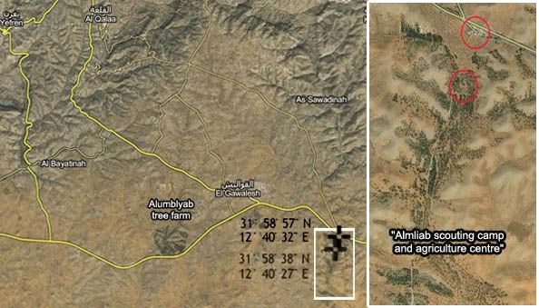
All this information was provided in a different context unrelated to the massacre discovered two months later (see below). But "Almliab" is similar enough in name, and the possible match good enough, that it's worth wondering, as Peet73 and I did, if this is what they meant.
Then I was tipped off to a comment I missed, by the same Algelawy2009 who specified Alumblyab. At this video's comments (same as cited above), the al-Qala'a native says "it is in Algalah in the area called Almlaeb” It almost seems that he's now specified both tree farms.
This Alumblyab/Almliab distinction can be a bit confusing, and I acknowledge I've got no certain answer to it. But here are the possibilities:
- There are two tree farm areas flanking Qawalish with very similar names
Or:
- The places are considered the same, with one name, just in two sections several miles apart.
Or:
- Wikimapia had it wrong (who plugs this info in and updates it?)
Or:
- Some other kind of linguistic mix-up, error, or misdirection.
Threat Positions
The June announcement via Shabbab Libya, mentioned above, was mainly to claim the opening of a supply line to Yefren and al-Qala’a from rebel-held Az Zintan, to bring “humanitarian” supplies to this front line, and asking for NATO air support to protect it. They also gave specific co-ordinates of government forces that "threatened [...] the region of Yefren and the Nafusa mountains."
Among the precise spots "threatening" (otherwise, defending) the area and its civilians was "Almliab forest (VERY IMPORTANT)." This is also called by them a "scouting camp and agricultural center," which housed a "large force including at least 4 tanks, grad, ammunition, personnel, etc. It is the main army supply to the area (substation) for forces heading west." Beyond this, they assured NATO that "command and control is highly suspected to be in one or more of the 4 buildings given."
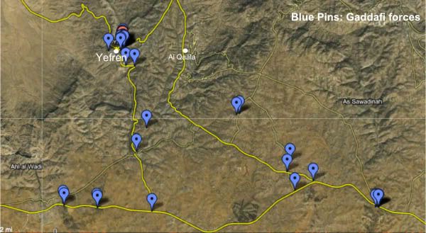 Map: Positions of Gaddafi forces near Yefren and Al Qalaa
Posted on May 25, 2011 by admin, at Libyafeb17.com.
This map, posted by Amazigh_Libya on May 22nd shows the position of Gaddafi forces around the towns of Yefren and Al Qalaa. The area has been under siege for 2 months.
http://www.libyafeb17.com/2011/05/map-positions-of-gaddafi-forces-near-yefren-and-al-qalaa/
One ImazighenLibya, probably not the same as this Amazigh_Libya, has an interesting involvement with protecting the rebel version of the tree farm massacre video, as explained here (last section). I mention that on the off-chance the Youtube activist is the same as this regional activist, using sources inside, one supposes, to show NATO where to bomb, perhaps. And also, perhaps, where to plant rebel victims in order to blame Gaddafi.
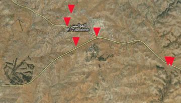
We can see this collation of whatever data pinpoints the Almliab tree farm base at the right edge with two pins, as well as four other spots around Qawalish, mostly at road intersections where there's nothing but a small shack. Simple check-points "threaten" the people of Yefren and Qala'a? And why, even in June, is the threat to closer-yet Qawalish not mentioned?
There are no pins that line up with the Alumblyab forest, for whatever that's worth.
Pinpointing the Locale: Later, Maybe
At the moment, it remains unsettled just where the video was filmed, let alone by whom. It is possible, hypothetically, to find a match from satellite imagery with the exact clearing shown in the video, in one or another of these tree farms. But I won't bet any time trying. The images used are are usually some years old, and while trees tend to grow many years in the same spots and patterns before being cut, they do get cut, and there's no guarantee what the videos shows will really match anything the satellite saw in the year 20whatever.
However, for what it's worth as a clue, there is a different type of tree visible, for only a frame or two, in only one direction - to the northeast as I have it, nearest "soldier" #4. I can't identify it yet. It doesn't look like an olive tree or a few others I considered. I'm open to suggestions.
It might be nothing but some mixed plating, or the start of someone's orchard blending a bit into the edge of the evergreen factory, helping set the location - near the forest's edge. Does the lighting pattern suggest the area further to the right is more open, with smaller trees and less canopy? I think it might. But again, I'm not planning to pinpoint the locale at this time.
The confusion over the location names is also unsettled. The same supposedly knowledgeable source seemingly gives both tree farm names to describe this one place, from the small area he comes from and "knows well." And the foreign-based rebel info conduit Shabbab Libya is pointing way to the north and asking for minesweepers already so someone can have a look there.
The confusion over the location names is also unsettled. The same supposedly knowledgeable source seemingly gives both tree farm names to describe this one place, from the small area he comes from and "knows well." And the foreign-based rebel info conduit Shabbab Libya is pointing way to the north and asking for minesweepers already so someone can have a look there.
Conclusion/Prediction
The requested rebel investigation in Benghazi will surely form and have a look, at both this and the newer, larger, Tawergah massacre of 150 civilians, blamed on Gaddafi, plus whatever other slaughters are "uncovered" as the rebel advance.
Only time will tell if they're able to say these 30 bodies were dumped in a forest (reportedly) used by Gaddafi's forces and, therefore, clearly killed by them. Time will probably say "yes, that's just what they found." I predict they will specify the Almliab scouting camp and agriculture center, and again blame the old regime.
Will the world still believe them? Or has the spell worn off?
Update, October 7: A Location guess
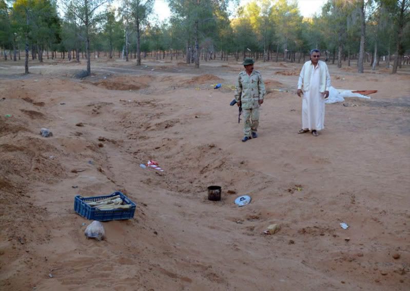
A photo of the scene I recently came across helps clarify enough details to let me make a guess for a specific mass grave location. The photo at left (original page) was taken Sept. 7 by Abdel Gassem Kreir, a Qalaa native and apparently also a photographer for the Associated Press. It shows the trench after its exhumation in late August. As far as trees go, it's mixed planting all around. What helps here, perhaps, are the roads visible.
I decided by the long shadows crossing the trench that it ran roughly north-south. To be more precise, presuming the video was shot in the morning, it would be rotated about 1:00 when seen from above, the north end pointing a bit east and the south end further west. That means the photo is taken looking about due south, and it shows a track road curving just twenty feet away from the trench's south end and western edge. Another, more major road is visible in the background. By the directions established, it runs roughly east-west. Its south side anyway has a cut bank - shallow, but noticeable.
This implied road intersection, with a minor road curving west and then north off a major east-west route might be useful. I scanned on Google maps all three forested areas around Qawalish, especially Almliab and Alumblyab, for areas that match. The major road made it easy to decide. Almliab doesn't seem to have a match for it anywhere - its main road runs south and only minor roads branch off east and west. Nothing at the forest behind the checkpoint just south of town seemed a fit either.
But the Alumblyab tree farm west of town has one area that fits the criteria, and only one that announced itself to me. It's got an east-west road with a cut bank on both sides, discernable by the irregular shadow along the south edge. It has a road branching off north into an area with a possibly consistent clearing. There's a faint trench in the topography there - oriented about 1:00, its apparent bottom highlighted in brown. I put the grave area in red (it seems to run into more level ground at the south end), and the rough angle of view and camera position in aqua.
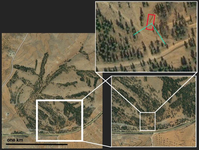
The problem with the road is evident - the one shown runs roughly straight north, with a branch to the northwest only outside our field of view here. There's nothing curving south of the trench like the one seen. What I propose is that a new road was blazed, about as shown here with the tan tracks. Such a road makes total sense for access reasons, and it fits with the photo. To the right should be about where the two roads would intersect, and we may see this here. The whokle area is flat and uncertain, covered with piles of earth from the dig, but with no trees. I think I see signs between the trees of that north road going back a bit, but that's not really certain.
Trying to match the trees has confused me, but my latest look suggests a view centered about due south might fit with the photo as far as where trees are nearer and further away. Perspective can be tricky at times like this.
Although compound uncertainties exist, I think this is the most likely single location, and worth venturing. The significance is this: the excavation, by several sources, happened at a forest/scouting camp behind a government check-point near al-Qawalish (see here). The location behind the check-point, where locals say they were detained and saw people beaten or killed, was the best clue this was the government's work. Well, that and the supposed ID match with several alleged detainees.
But the scouting camp is at Almliab, southeast of town, and this patch is at Alumblyab, to the southwest. There were no government facilities listed for this forest, and likely little or no access control. Anyone could have dumped bodies there, maybe even in June. Asof July, the rebels were the only ones in a good position to dump anyone anywhere.
If I'm right and there's a disconnect still, with confusion over the locale being perpetuated, it's worth asking why.
You're right, we thougt to early it's all the same. If there are different consonants in the names, they are probably not the same ones, vowels are usually less important.
ReplyDeleteI found the name "Alme'aaeb camp" for a location southwest of al-Qawalish on an other map, but it's not realy clear and perhaps only just more confusing. Have a look here and pop up the map by clicking:
http://voicefreelibya.blogspot.com/2011/06/freedom-fighters-tried-to-force-out-al.html
The anouncements these "investigators" made about the location are realy a mess. Why? They anounced to have the filmmaker as a "POW". I'm very curious when they will give the Human Rights Groups access to this guy - it should be their own aim to do that qickly and to spread this story.
Why is nobody reporting about this? Despite the press release it's still exclusive in your blog. Why haven't the NATO PR officers pushed the story to the media and the politicians? Are they just waiting for the right moment or are they afraid it will be a boomerang?
It wasn't unreasonable to presume they were the same. I find it odd there are two areas so close with almost the same name, phoenetically. Plus a third fairly close in name and space.
ReplyDeleteLooked at that map. It's clearly indicating the eastern one as well. The larger Alumblyab is visible to the right of the lettering, and closer to due south of the QY area.
The silence really is deafening. This means people don't believe the rebels (around Qawalish) anymore but yet don't want to know anyway. Silence and lockstep now until the job is done, and only then will there be time for more questions and possibly regrets.
I'm keeping an eye out for news on this, but Tawergha's hundreds might be taking attention away now, and rightly so.
On second thought ... it seems to say Alm'aaeb camp, which seems odd. Might just be a typo, but it's also not at either forest spot, but the crossroads south of Qawalish, which seems to be misplaced, too far east. By this, taken literally, there was no force at either forested area.
ReplyDeleteI started to include it until I looked closer and noticed these things - maybe an oddball clue, but it adds confusion, where there's already enough.
Not sure where to post this, but the Nefusa Mountain Media Group, which joined the NTC in May, has an archived of events from their perspective, (mainly active April - July) and some video links from Facebook e.g. this video of someone being hooded and abused in the back of a pickup in mid June and also here (Sunday June 19, 2011 17:29h:Nafusa Mountains: Yefren: "Gaddafi forces humiliate detainees" near Al-Awaynia.
ReplyDeleteThe site calls Qawalish GWALISH or AL GAWALEESH e.g.
Thursday June 30, 2011 14:51h:
Nafusa Mountains: Kikla & Yefren: Gaddafi brigades in Gwalish bombed Kikla. Gaddafi forces located in Bir Al-Ghanam bombed Bir Ayyad this morning...
Some videos, eg.here purport to show Gaddafi soldiers
Sunday June 27, 2011 20:18
Nafusa Mountains: NATO aircrafts strike Gaddafi forces located in Al Gawaleesh destroying 8 of their vehicles. Following NATO strikes, Gaddafi forces in Al Gawaleesh violently launch Grad missiles on the area of Thaher in AlQala’a.
Thursday June 16th, 2011 19:26
Nafousa Mountains: Al Gawaleesh: Heavy shelling by coalitions forces of Gaddafi forces in new buildings of Al Gawaleesh area used as their weapons storage. Several explosions were heard and thick smoke was seen rising.
Footage here of the weapons store being sprung in القاعة or Al Qa'a (Ga'a)
Monday June 20th, 2011 11:41h:
Nafusa Mountains: A Qatri Emir has donated 40 SUVs to the freedom fighters of the Nafusa Mountains
Quite a few links are buried under more...
www.libyafeb17.com/2011/06/june-1st-upd...
ReplyDeleteAl Galaa: Revolutionaries there ambushed soliders and mercanaries on patrol in the area of Hawaza and killed many mercenaries
The revolutionaries returned safely back to there bases and bobardment by Gaddafi forces continues
http://www.libyauprisingarchive.com/61---68-from-a-good-source.html#/
Yifran Galaa June 4, 2011 On Friday, the rebels entered the town to find that the last government forces had fled the day before.
ReplyDeletehttp://www.columbian.com/news/2011/jun/04/british-french-helicopters-bomb-gadhafi-troops/
But the helicopters are a game-changer, giving the alliance a key advantage in close-up combat, flying at much lower altitudes.
NATO quoted Lt. Gen. Charles Bouchard, commander of the Libya operation, as saying the engagement "demonstrates the unique capabilities brought to bear by attack helicopters."
The strikes came after Libyan rebels on Friday won control
of four towns in the western Nafusa mountain range
23 Jun 11 NATO has damaged or destroyed 2,400 military targets,"Rasmussen told France's Le Figaro newspaper.
*
Mohammed Ramadan al-Barghout, 34, a physics teacher,
told Human Rights Watch on September 10
that he had been detained by Gaddafi loyalists at his house in Umm el-Jershan in early June and taken to the Scouts base
http://jerbanews.blogspot.nl/2011/09/libya-mass-grave-yields-34-bodies.html
6 june Al-Gal’a
http://twitpic.com/4g3xdj/full
http://www.facebook.com/note.php?note_id=158699667530713&comments
Monday 6 June, 12:25 h
Nafusa Mountains: Al-Gal’a: Battles are ongoing between freedom fighters and Gaddafi forces in the outskirts of Al-Gal’a
Monday 6 June, 04:00h
Nafusa Mountains: Al-Gal’a: Freedom fighters are still surrounding the Gaddafi forces in the Saffeet area in Dahar Al-Gal’a region.
http://northafrica.humanitarianresponse.info/sites/default/files/110627_OCHA_Nafusa_Factsheet.pdf
*
{..] Col. Jumaa Ibrahim of the region's rebel military council said rebel fighters won control of the towns of Yefren, Shakshuk, Qasr Al Haj and Al-Galaa, allowing them to secure a key road that would allow humanitarian and military supplies into the area for the first time in weeks.
http://online.wsj.com/article/SB10001424052702303745304576364910965100534.html
*
June 6, 2011 Khwaldi Hmeidi G aide in1969coup&strong man in west Libya has been seriously hit in NATO strike on his barraks in Surman,20km west of Zawia
Al Qawalish 6/07/2011 a pair of dirt roads leading to a boy scout building known as al-Malayab,
ReplyDeleteAt least three minefields containing antipersonnel and antivehicle landmines were found
on the outskirts of al-Qawalish village in the Nafusa Mountains.
Two of the minefields were laid near each other on a pair of dirt roads leading to a boy scout building known as al-Malayab,
west of al-Qawalish(coordinatesN 31 ̊ 58' 50.79" E 12 ̊ 40' 32.23" and N 31 ̊ 58' 50.74" E 12 ̊41' 26.26").
On July 6, after the rebels seized the area, three rebel vehicles struck mines on the dirt roads.
The vehicles were destroyed and three people were wounded, two of whom were hospitalized.
By the end ofJuly 7, deminers had uncovered about 240 T-AB-1 antipersonnel mines and 46 Type-72SPantivehicle mines.
The third minefield was laid along the main asphalt road to al-Qawalish, west of al-
Malayab(coordinates N 31 ̊ 59' 2.26" E 12 ̊ 40' 29.58")
All three minefields are in areas with civilian traffic, but they were marked by rebel fighters to prevent people from entering them
. When Human Rights Watch visited the site,deminers had not begun work, but a vehicle that appeared to have been damaged by an antipersonnel mine lay by the road
http://i42.tinypic.com/2a8rrf5.jpg
ReplyDeleteA rebel commander, Alejmi Ali Ahmed, with Type-72SP antivehiclemines, produced in China, and T-AB-1 antipersonnel mines,produced in Brazil, removed on July 6, 2011,
from two minefields west of al-Qawalish village in the Nafusa Mountains.
*
Human Rights Watch reported that Muammar Gaddafi's forces laid both antipersonnel and
antivehicle mines a few meters off the side
of the main road on the eastern outskirts of
Ajdabiya in late March, after at least two dozen antivehicle mines and roughly three dozen
antipersonnel mines were found by electric company repair crews.
The types of mines found include Brazilian-produced low-metal-content T-AB-1 antipersonnel mines and Chinese-produced metal-cased Type-72SP antivehicle mines.
http://www.hrw.org/sites/default/files/related_material/Download%20the%20Landmine%20Technical%20Briefing%20Note_1.pdf
Do we meet rebel commander " Alejmi Ali Ahmed "
Deleteon 19- 3 - 2011
@ 0.55 @ right
http://www.youtube.com/watch?v=HS2GEfjCca8
Battle for Al Qawalish [6/07/2011 Reuters] معركة تحرير القواليش
ReplyDeletehttp://www.youtube.com/watch?v=r0rwvktbh6k&feature=player_embedded
http://i42.tinypic.com/2a8rrf5.jpg
@0.59 " Alejmi Ali Ahmed"
@ 1.03 this advance follows weeks of static fighting
the previous big advance in the region was last month when rebels took a town 20km north of their base in the western mountains
*
6 juli 2011 Captured Town of al-Qawalish Destroyed by Rebels
http://secure.corbisimages.com/stock-photo/rights-managed/42-29058956/libya-war-captured-town-of-alqawalish-destroyed
A rebel fighter points to the arabic word "Mashaashi" on the wall.
The Mashaashi are a tribe thought by the rebels to be loyal to the Qaddafi regime, who were moved to certain villages in the western mountains between 20-30 years ago by Qaddafi.
RRowleyTucson Robert Rowley
ReplyDelete#NATO airstrikes audible east of #Qawalish today. Aircraft overhead. Three large explosions midday. #Libya #feb17
Revolutionaries in the mountains seized the village of Al-Qawalish from Gaddafi’s forces last week
And when Qwaleesh was freed, 8 died from Zintan, and 1 from Kikla..they called it 9 dead from nafusa..Zintanis say they want their due…
In the last few hours…G forces tried to out-flank FF in Qawleesh…it failed epically…they managed to stop it quite easily.
They have now managed to capture a very large number of prisoners..currently being held in Kikla..unsure what to do with them..
ChangeInLibya
Gaddafi forces that thought qualeesh was empty and saw scout team running away fell for a huge ambush
Although it remains unclear which forces were in command of the Scouts base
ReplyDeleteThirty-four bodies exhumed from a mass grave near the town of al-Qawalish in western Libya seem to be those of men detained by pro-Gaddafi forces in early June 2011, Human Rights Watch said today.
http://jerbanews.blogspot.nl/2011/09/libya-mass-grave-yields-34-bodies.html
During a visit by Human Rights Watch to the region shortly after pro-Gaddafi forces had fled the area on July 6,
the new authorities in towns near al-Qawalish furnished the names of 173 missing men, including 81 from al-Qal’a.
Twenty-seven of the 34 bodies were subsequently identified.
*
A group from Galaa, aided by a team from the Red Cross, began exhuming the bodies Aug. 20.
Kreir said the remains were still in the same position as in the video
After 10 days of digging, the bodies were laid to rest Wednesday in a special cemetery in Galaa
*
Who laid the bodies to rest in june or july?
The exhumed bodies were blindfolded with hands tied. The discovery of bullet casings at the site suggests the captors shot the men with automatic gunfire before burying them in a shallow common grave.
Deletehttp://www.hrw.org/news/2011/09/14/libya-mass-grave-yields-34-bodies
http://www.youtube.com/watch?v=mOgyqLTqZ5I&feature=BFa&list=ULBFKLXkwscdU&skipcontrinter=1
ReplyDeleteUploaded by QuatchiCanada on Aug 6, 2011
34 civilians were executed by Gaddafi's forces in the area of Daher in the town of Qalah in the western mountains of Libya.
They were kidnapped and executed at the Malaeib farm near the gates of Sowadna.
The person speaking is one of Gaddafi's mercenaries. He calls the people he killed "The Rats" as he films them.
هولاء الشهداء اخططفوا من منطقة ظاهر القلعة وتم قتلهم قتل جماعي في منطقة مزرعة المليعب بظاهر القلعة بالقرب من بوابة االسوادنة من قبل كتايب المجرم القدافي
In mid-August, Abdel Gassem Kreir,
a photographer in Galaa, said he saw cellphone video on YouTube showing a group of bodies, most of them bound and face-down, in a familiar-looking wooded area.
http://www.thejakartapost.com/news/2011/09/10/libyans-find-mass-grave-bodies-slain-detainees.html
ReplyDeletehttp://www.youtube.com/watch?v=BFKLXkwscdU&feature=BFa&list=ULp6b-D6L23eg
[Tuareg army men ] Dead Gaddafi's Mercenaries on July 6, 2011, Ghwaleish (Libya) القواليش
Uploaded by QuatchiCanada on Jul 6, 2011
@ 3.52 3.53
Libya, 6 July 2011, Hamlet of "Al Qawalish" (Nefusa Mountains) (http://g.co/maps/hsmg4)
Touareg mercenaries from Mali (Azawad) units of Gaddafi's mercenary brigade "Al Fooj Attassa3" (كتيبة علي سليمان كنّه الفوج التاسع) neutralized by Libyan Freedom Fighters at the battle of Al Qawalish,
a hamlet from where these mercenaries have been shelling the cities and civilian populations of Kikkla, Al-Qalaa, Yefren and Zentan for months.
http://www.youtube.com/watch?v=eTQjuVLY2l4
C.J. Chivers: This needs to be addressed by TNC: Scenes from Qawalish, Libya.
The destroyed gas pumps, which were intact and functional when the Forces of Free Libya captured the town from the military forces of Col. Muammar el-Qaddafi last week.
Bryan Denton and I were in the town within minutes after it fell, we returned the day after and we returned again today.
During this time the town was solely under rebel control.
And during this time it has been looted extensively, including by armed men we observed in rebel attire and in vehicles bearing rebel stickers or flags.
During this same time, many houses have been burned.
We have been unable to locate a single civilian in the town.
Perhaps a few are there, well-hidden or checking briefly on their belongings.
Most have fled.
Rebels roam the town and man checkpoints that control access to Qawalish, and have not shown concern for this.
cjchivers.com/post/7473082598/scenes-fr...
1. ALGALAA
ReplyDeleteA. Almliab forest (VERY IMPORTANT)
Position: 31°58’38.03″N, 12°40’26.62″E
Site: on left hand side when going from Gharian to Nalut on motorway.
Force: Large force including at least 4 tanks, grad, ammunition, personnel, etc. It is the main army supply to the area (substation) for forces heading west.
Method of observation: eyewitness
Time: Thursday May, 19
A. Command and Control centre at Almliab forest
Position(s): 31°58’59.04″N, 12°40’30.84″E
31°58’58.35″N, 12°40’32.39″E
31°58’57.80″N, 12°40’33.29″E
31°58’57.84″N, 12°40’34.21″E
Site: Almliab scouting camp and agriculture centre.
Force: Command and control is highly suspected to be in one or more of the 4 buildings given above.
Observation: eyewitness
Time: Saturday May, 21
B. Frandis Junction (Very important)
Position: 31°59‘44.33″ N, 12°38‘16.98“ E
Site:
Force: Army (different equipments and soldiers)
Method of observation: eyewitness
Time: Saturday, May 21
C. Ali Suleiman Junction
Position: 31°59‘27.13″ N, 12°37‘38.86“ E
Site:
Force: Big Grad missile launcher, personnel, heavy machine guns
Method of observation: eyewitness
Time: Saturday, May 21
D. Alajaylia Junction
Position: 32°00‘00.43″ N, 12°37‘22.43“ E
Site:
Force: 2 tanks, grad rocket launchers, personnel (check point), heavy machine guns
Method of observation: eyewitness
Time: Saturday, May 21
E. Omar Shawesh hill
Position: 32°00‘20.05“ N, 12°37‘28.41“ E
Site:
Force: grad missile launchers, personnel, heavy machine guns, hidden tanks
Method of observation: eyewitness
Time: Saturday, May 21
F. Saffit hill (VERY IMPORTANT)
Position: 32°01‘41.82“ N, 12°35‘36.38“ E
Site: Relatively, vey high hill
Force: 1 grad missile launcher, 4 tanks, mortar, personnel, heavy machine guns
Method of observation: eyewitness
Time: Saturday, May 21
G. Alazzaba hill (VERY IMPORTANT)
Position: 32°01’44.68″N, 12°35’41.88″E
Site:
Force: Grad missile launchers, personnel
Method of observation: eyewitness
Time: Saturday, May 21
2. YEFREN
ReplyDeleteA. Forest near Awiniya
Position: 31o59’00.84” N, 12o29’36.16” E
31o59’05.29” N, 12o29’34.24” E
31o58’56.64” N, 12o30’45.62” E
31o59’00.49” N, 12o30’44.18” E
Site: Forest on both sides of Gharian-Nalut road near to Awiniya village
Force: Large army force with various equipment and personnel
Method of observation:
Time: Saturday, May 21
B. Al-Ghnayma cross road
Position: 31o58’50.93” N, 12o32’39.33” E
Site: Off Gharyan-Nalut motorway, to the north.
Force: Troops
Method of observation:
Time: Saturday, May 21
C. Romiya (VERY IMPORTANT GATE TO YEFREN)
Position: 32o00’36.80” N, 12o32’06.99” E
Site: T-cross roads
Force: heavy machine guns on trucks, and possibly 1-2 tanks
Method of observation: telescope
Time: Saturday, May 21
D. Road to Romiya: Old Bridge
Position: 32o03’08.83” N, 12o32’03.21” E
Site: On the turn on way to Romiya after the petrol station.
Force: Toyota mini-grad missile launcher, heavy machine gun(s). Possibly, a tank.
Method of observation:
Time: Saturday, May 21
E. Road to Romiya: Buashra
Position: 32o03’08.94” N, 12o31’45.78” E
Site: Just on the way from Yefren centre to Romiya after the petrol station. About 100 meters after the fuel station when driving from Yefren to Romiya, on the same side of the fuel station. Workshop buildings are used to hide tanks and army equipment.
Force: Toyota mini-grad missile launcher, heavy machine gun(s), personnel. Sometimes bmb soldier vehicle. Tanks.
Method of observation: telescope
Time: Saturday, May 21
F. Romiya- Suleiman Gjam Summer House
Position: 32o01’18.37” N, 12o32’28.82” E
Site: Summer house of Leader of Central Support Police
Force: Suspected to be used for command and control. It has heavy machine guns on trucks, 1 soldier carrier and 1 or more tank(s) in its vicinity.
Method of observation: telescope
Time: Saturday, May 21
G. In front of Main Post Office
Position: 32o03’37.03”N, 12o31’34.13” E
Site: In T-road in front of post office which is located by the beginning of the road to Romiya and by the police station.
Force: 1 tank, heavy machine guns
Method of observation:
Time: Saturday, May 21
Note: there are half hourly patrols between post-office and position (F, above) back and fore
H. Yefren Main Post Office
Position: 32o03’38.03” N, 12o31’35.09” E
Site: By the beginning of the road to Romiya and by the police station.
Force: Snipers
Method of observation: Eye witness and telescope
Time: Saturday, May 21
I. Police station
Position: 32o03’35.99” N, 12o31’09.67” E
Site:
Force: storage, personnel.
Method of observation:
Time:
J. In front of Army Camp
Position: 32o03’40.33” N, 12o31’41.50” E
32o03’42.66” N, 12o31’38.66” E
Site: In parking in front of Yefren Army Camp and near old traffic police station
Force: at least 2 tanks, heavy machine guns on trucks.
Method of observation:
Time: Saturday, May 21
K. Yefren Army Centre
ReplyDeletePosition: 32o03’41.68” N, 12o31’41.50” E
32o03’42.18” N, 12o31’43.09” E
Site: This is an old Italian army building that was used for several purposes afterwards, with latest being a local Yefren Army centre. Information highly suspect that it is also used by high Gaddafi army officials. The first position defined above has offices used by high army officials and the second one is the store of light arms and possibly ammunition.
Force: Heavy machine guns on trucks, tanks, and others
Method of observation: Eye witness
Time: Saturday, May 21
L. Yefren Fire brigade
Position: 32o03’41.54” N, 12o31’41.84” E
Site: This is an old Italian administration building that was used for several purposes afterwards, with latest being a local Yefren Fire brigade. Information highly suspect that it is also used by high Gaddafi army officials. We do not have information as to exact location of control office(s) in this building.
Force: Heavy machine guns on trucks, tanks, and others
Method of observation: Eye witness
Time: Saturday, May 21
M. In front of Yefren Central Garden
Position: 32o03’42.16” N, 12o31’34.81” E
Site: In the road between administration buildings near Central Garden.
Force: A truck with heavy machine gun, personnel or tank
Method of observation: Eye witness and telescope
Time: Saturday, May 21
N. Yefren Hospital
Position: 32o03’48.08” N, 12o31’37.29” E
32o03’52.66” N, 12o31’38.65” E
Site: In front of main hospital gate and behind the hospital, army forces. The hospital is not any more functioning as a hospital but rather an army centre and arms store.
Force: Trucks with heavy machine gun(s), personnel.
Method of observation:
Time: Saturday, May 21
O. Yefren Hospital Offices
Position: 32o03’50.43” N, 12o31’39.57” E
32o03’48.08” N, 12o31’37.29” E
Site: In outpatient clinic (first position) and separate new building, behind the hospital main complex (second position). High ranking military officers were witnessed going in and out from these buildings in the last few days. It is believed that command and control may be taking place here.
Force:
Method of observation: Eyewitness
Time: Saturday, May 21
P. Zemla –Sasi Grada Home
Regards,Abdo. Al Herrari abdodo56@yahoo.com Libya Hurra’s Abdo Al-Herrari
http://theshared.net/an-appeal-for-help-to-nato-and-the-icrc-from-libyan-civilians-in-need-of-humanitarian-aid/
17 -25 July 2012
ReplyDeleteFormer rebels determined to continue their score settling
frequently hunted down the 30,000 Tawarghans displaced all over Libya
http://migs.concordia.ca/Media_Monitoring/documents/LibyaDomesticMediaMonitoringReportJuly17-25.pdf
The Mshashiya and Qawalish tribes from the Nafusa Mountain area
have suffered a similar plight.
Opposition fighters from Zintan waged revenge attacks, which resulted in hundreds
of deaths in June 2012 alone, against the members of these tribes
for alleged loyalty to Gaddafi.
After rebels gained greater control, many tribal members fled for Tripoli and continue to live as internally displaced refugees for fear of returning home.
As of 8 September 2014, at least 56,544 people have been in protracted displacement since the 2011 conflict that ended Muammar al-Gaddafi's 41-year rule (OCHA, 28 February 2014; IDMC interview, 8 September 2014).
According to UNHCR, this figure includes approximately 40,000 Tawerghan IDPs, the majority of whom were staying in Tripoli or Benghazi.
It also includes approximately 9,200 IDPs from the Mashashya, Qawalish and Sian tribes who remained displaced in the Nafusa Mountains (IDMC interviews, 9 and 19 September 2014). Those who fled Tripoli and the nearby town of Shgeiga, continue to live in dire condition in schools, unfinished administrative buildings and metal hangars, which they have been squatting since October 2011. Members of these communities have been accused of being supporters of the Qaddafi regime by armed groups and have been victims of retaliatory attacks.
http://www.internal-displacement.org/middle-east-and-north-africa/libya/figures-analysis
http://libyancivilwar.blogspot.com/2012/06/attacks-on-chakika.html
Wednesday 15 June, 16:38 hrs
Nafusa Mountains: Al-Awiniyah: National Army and freedom fighters have attacked Gaddafi forces in Al-Awiniyah. Gaddafi mercenaries have fled towards Shagiga in the south. Freedom fighters are now carefully checking the area to ensure that no mercenaries were left behind
Awaniya as a base
The elders in Zintan say that they had negotiated three times with the Mashashiya elders since April, and that the latter had agreed to remain neutral. But Gadhafi's soldiers apparently used Awaniya as a base for their tanks, firing Grad rockets from there at the civilian population of Zintan and the surrounding villages for months. The tribes have been at war with each other ever since.
http://www.spiegel.de/international/world/settling-old-scores-tribal-rivalries-complicate-libyan-war-a-776695-2.html