Warning

Warning: This site contains images and graphic descriptions of extreme violence and/or its effects. It's not as bad as it could be, but is meant to be shocking. Readers should be 18+ or a mature 17 or so. There is also some foul language occasionally, and potential for general upsetting of comforting conventional wisdom. Please view with discretion.

Monday, October 10, 2022

One Month of "Russians Shelling Themselves" in Donetsk

October 10, 2022

(rough, incomplete) last edits 10/18

In my previous post on the September 19 Donetsk shelling attack and related tweets, I noted some other attack scenes that came attached to some reports. A market area and 2 homes probably do relate to that day. But a burning truck was actually 2 days earlier. Other scenes on different days I saw along the way to figuring that out were intriguing. There were more than the six seven incidents I'll cover here, spanning almost exactly one month from August 23 to September 22. 

Local authorities and Russian sources generally report these as UAF fire from the northwest, where Ukrainian forces have for years encircled and allegedly terrorized the city. that, while pro-Kiev sources cast doubt or overtly blame Donetsk Peoples' Republic forces or their Russian allies for the shelling, intentionally, as a "provocation" just to make Ukraine look bad.

Applying quick but sound ballistic analysis to available images, I find that - with one unexpected exception - the shells in these attacks that killed dozens of locals and wounded many more appear to have originated from the northwest, at a few different angles. It's still physically possible DPR or Russian forces could have carried out these attacks from around the NW limits of Donetsk. But that was always a stupid victim-blaming conspiracy theory that seems to cover for ongoing, somewhat genocidal state-sponsored terrorism.

August 23, Clashing Claims:

https://lenta.ru/news/2022/08/23/damage/

"Ukrainian troops shelled the building of the administration of the head of the DPR in the center of Donetsk. "A fire broke out in the building. Broken bricks, parts of cladding and metal structures are scattered everywhere in the district, "eyewitnesses said. The head of the DPR Denis Pushilin was not injured."

Including other shelling this day, "the number of civilians affected by the shelling increased to eight people. The mayor of the city of Donetsk, Alexei Kulemzin, said that two people were killed and six people were injured from the next blow of the Armed Forces of Ukraine, they are provided with the necessary medical care."

https://focus.ua/voennye-novosti/526415-pryamoe-popadanie-v-donecke-nanesli-udar-po-administracii-pushilina-foto-video

The Russian authorities could organize strikes on the occupation administration of the head of the "DPR" Denis Pushilin on August 23 in Donetsk. Their goal is to justify the attacks on Ukrainian government buildings on Independence Day. This is written by analysts from the Institute for the Study of War (ISW).

Some conspiracy theorists there. Did they really say that?

https://www.understandingwar.org/backgrounder/russian-offensive-campaign-assessment-august-23

By Karolina Hird, Kateryna Stepanenko, Grace Mappes, George Barros, and Frederick W. Kagan

Russian officials may have conducted a false flag event in Donetsk City on August 23 to justify attacks against Ukrainian government buildings on August 24, Ukrainian Independence Day. Social media networks in Donetsk City reported that a strike caused damage to the Donetsk People’s Republic (DNR) administrative building, where DNR Head Denis Pushilin works.[11] Pushilin was reportedly absent at the time of the strike. Russian media framed the attack as a direct Ukrainian strike on a DNR government building, potentially to set information conditions for retaliatory strikes against Ukrainian government buildings on Ukrainian Independence Day.[12] 

August 23, Cameras Not Lying:

Location: south part of Voroshylovs'kyi district, on Puskina blvd. - 47.9972727,37.8021528 - 2011 street view below - this is the west-facing facade, hit in 2 spots- I think from the left/north. Either way, it must be partly from the west. 
Someone else could say a lot more about this, especially with more than the one image. I suppose a Russian false-flag attack is physically possible ... they run areas to the northwest just past Donetsk city limits, around 8-12 well-inhabited kilometers from this building. They would want to make it look like the Ukrainian "Nazis" did it right? If so, they succeeded, because ... it looks like the Ukrainians "Nazis" did it. In better detail, the following cases tend to look just the same.

September 2: Clashing Claims

https://www.mk-donbass.ru/incident/2022/09/02/centr-donecka-popal-pod-obstrel-vfu-est-zhertvy.html

As the mayor of Donetsk said in his official telegram channel, the AFU again struck at the center of Donetsk. Under fire was the Voroshilov district of the city.

According to eyewitnesses, the shells exploded near the drama theater. Another shell hit the roof of a new building on Pushkin Boulevard.

https://www.donetsk.kp.ru/online/news/4903749/

"As of 23:30, the total number of civilian casualties from attacks by armed formations of Ukraine for September 2, 2022 is 21 people, including 1 child," the observers said. 

It is specified that six civilians, including a child, were killed, another 15 were injured. "Unfortunately, the injured child born in 2008 died on the way to the hospital," the mayor's office informed. It is noted that the teenager was injured in the shelling of the supermarket "Obzhora" in the Kalinin district of Donetsk.

It is also reported that as a result of the shelling of the center of the capital of the Republic, the glazing of the building of the Donetsk State Academic Music and Drama Theater named after M.M. Brovun, as well as the building of the Apparatus of the DPR People's Council, was damaged.

- In the underground passage, trade pavilions, the front door, the guard's room, the shield room were damaged. The roof of an apartment building was damaged due to a direct hit, - the head of the capital administration Alexei Kulemzin said in his telegram channel.

September 2: Photos Not Lying

Parking lot of Donetsk National Academic Ukrainian Music and Drama Theater next to Pushkin monument (as located for 9/17, see below). Also in the central Voroshylovs'kyi district

Pretty clearly from the northwest. See site mapping below to save pic space. Facing north, just west of the theater's west face, an impact near the corner spread - the blast wave bent the sign forward, as debris was sent ahead and to the left and right. 

September 9: Clashing Claims

IN DONETSK, A BUS STOP NEAR THE PARK WAS SHELLED: THERE ARE DEAD AND WOUNDED

On the afternoon of September 9, the center of occupied Donetsk came under fire. The second wave occurred in the area of the intersection of Universitetskaya Street and Prospekt Mira. Nearby is the Park of Forged Figures. According to preliminary data, as a result of the shelling, 2 people were killed, 5 were injured. Data on victims and wounded are being clarified.

Earlier it was reported that the Park of Forged Figures in the city center came under fire, as a result of which a woman was injured.

The occupied Donetsk was shelled for the second time in a day. There are dead - September 09, 2022 :: News of Donbass (novosti.dn.ua)

the rest forthcoming ... to do: locate more reports, place the scene, assess the damage.

park and streets are just as given and the scene here is at 48.0168445,37.7988095 - northern Voroshylovs'kyi district. Google and Yandex street views are dated, showing different structures on the island, but the same apartment building across the way, and other surroundings that match video of the scene.

Crater: on the island's east side, with a loose splash of heavy marks just this side of powdered concrete and debris to the west and south. 

Unusually, it looks like this shot was fired from the east to northeast - behind DPR lines from the direction Maakiivka, by the line I drew here. It's just approximate, but still ... whatever happened here, it appears to me it's hard to blame Ukrainian forces for it. It isn't impossible to fire from behind enemy lines, just rather tricky and quite rare.

video: https://twitter.com/ara_n_ura/status/1568267686546735107 - dead victim on the ground just ahead of impact - another shell explodes behind the camera, just to the east - smoke rises from near the park's edge. 

September 17: Clashing Claims

https://www.mk-donbass.ru/incident/2022/09/17/v-dnr-pokazali-posledstviya-obstrela-centra-donecka-foto.html

Today, the AFU inflicted a massive artillery strike on the center of Donetsk. Pushkin Boulevard, the central Lenin Square and the adjacent section of Artema Street came under enemy fire. ... The shelling damaged the roof of the Voroshilov administration, the pedestal of the monument to Pushkin, glazed musical dramas and a number of other buildings.

...According to the JCCC of the VFU, they fired from guns of 155 mm caliber. Four people ["civilians"] were killed, three more were injured of varying severity. Two of the dead were burned in a GAZelle that was moving along Artema Street during the shelling. Another woman died near the drama theater.

Powerful explosions were heard in the Voroshilov district. Propagandists have already determined that 155 mm ammunition was fired at the city. ... During the shelling of the temporarily occupied Donetsk, the buildings of the "Ministry of Emergency Situations", ambulance stations and official vehicles were damaged. This was reported by the Russian agency "RIA Novosti".

https://www.ostro.org/general/society/news/647293/

"As a result of the provocation of the "DPR" militants in the occupied Donetsk, four people were killed. ... As always, the puppet authorities of the "DPR" stated that the shelling of Donetsk was carried out by units of the Armed Forces of Ukraine."

"In the Voroshilov district, fragments from the shells of the Caesar howitzer of French production were found - approx. DAN). It is already known about four dead," they said.

However, photos published in the separatist media of the places of arrival of ammunition refute the version of the shelling of Donetsk by large-caliber howitzers of NATO production. The pictures show minor destruction of sidewalks, the pedestal of the monument to Pushkin and broken window panes. By their nature, the places of arrival correspond to the shelling from mortars, the insufficient range of destruction of which excludes the use of this type of weapon by the defenders of Ukraine.

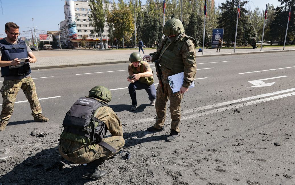
September 17, Cameras Not Lying: I found the spot from a few images before I checked what was said - Artema Street, Lenin square, central Voroshylovs'kyi district. 2 impacts. One with the heavily damaged and burning ("GAZelle") truck is widely seen from several angles. 

Location: in the street alongside Lenin Square - 48.0014395,37.804561. To the south: DPR People's Council building, damaged 9/2. 


Splash Pattern: A mess of chipped pavement with an ill-defined but generally coherent forward edge line angling less than 45 degrees relative to the white line ... frags would angle forward, up, and into this truck, in its original position a couple meters back. Other photos show gravelly debris across the street for a wide span and into the square, somehowhat behind/south of the truck.

North impact - seems almost due west across from the square's north and the green-marked building, and a bit north of all 5 flags.   splash pattern: not fully clear, but this soldier sits near the center and we can see the forward right edge of the chipped asphalt.

Music and drama theater, monument to (Russian poet) A.S. Pushkin. Impact to curb 4 or 5m NW from the bust of Pushkin gracing the square. Curb was blown away there, with fragments out the side craping various lines across the pavement to the right, as soil and a shrub absorbed the forward force of the blast, covering the sidewalk in a pattern that's been swept away by this view,


The line of marks on the brick runs - on a line similar to that of shadows here - back to the base of the actual bust of Pushkin, where the circular base is chipped, along with the square base above that, and the bottom of the pillar - in a line angling up to the southeast. Included with all 3 spots mapped with patterns and apparent shell trajectories traced on. 9/2 attack also noted. The memorial one is especially approximate here - I tried using ctrl to make a default 45-degree line, but it's not quite that. 

More exactly on the monument: at this scene, measuring from missing curb nearly to the NE corner of the bust's square base gives a line exactly to 211degrees SW. The flight path will be roughly perpendicular to this, so from around 300 degrees NW. My visual estimate for the road impacts as above seemed good, and was extremely similar to this. I'm calling all 3 fired from about 300 degrees NW. 

Note: "minor destruction of sidewalks, the pedestal of the monument to Pushkin and broken window panes" were mentioned as the only damage from these shells - but this was all from the one shell with little nearby to mark its presence except solid ground and the bottom of the pedestal. Broken windows distance: spanning ~42-50m away from the impact point. Is that really too weak for 155mm shell?

September 18 (a 7th incident, added 10/17) Video: Direct hit to the apartment on the street University, 53a. https://t.me/itsdonetsk/30974 - https://vk.com/wall-75188516_1005220 - no massive damage, but an impact near the corner, windows out all over this side of the building. 

Somewhere there was a suggestion this was done by Ukrainian forces to the northwest. V. Zolkin on Telegram had to expose that lie because "stupid countrymen have been pissing me off for the ninth year!" He cites the video, gives the spot, and says this is the east face (facing to Artema street to the east) and so the building was hit from NE, Kalinins'kyi district or Makiivka. As he points out in caps lock, there is no known AFU presence there. 

I'd say it was hit from the southeast if this were the east side. But in his anger, perhaps, he got it backwards. The spot on Google Earth is not a certain match, but it was given and seems consistent. It could be the east or west face we see - maybe west, as it's more heavily treed. Most details aren't all that clear, but one is: there is no low structure on the south end protruding a bit to the east. But there is its opposite - a low structure on the north end protruding a bit to the west.  Hit on the west side, from north (venturing no specific angle), and probably from AFU areas there, Volkin's un-abatable anger aside. 

September 19, September 22: mostly forthcoming...

https://meduza.io/feature/2022/09/20/voyna-dvesti-vosmoy-den-fotografii

"On September 19, the authorities of the self-proclaimed LPR and DPR proposed to immediately hold referendums on joining Russia. ... The mayor of Donetsk, Alexei Kulemzin, reported the death of 13 people as a result of shelling of the city by the Ukrainian military." 

В Донецке во время артобстрела погибло много людей, боевики обвиняют ВСУ (фото, видео) (focus.ua)

In the Kuibyshev district of Donetsk on the afternoon of August 19, "arrivals" from artillery shelling were recorded. The "mayor" of the city, Alexei Kulemzin, appointed by the occupiers, accused the Armed Forces of Ukraine of shelling.

Referring to the data of the joint center for control and coordination of ceasefire and stabilization of the demarcation line of the parties, Kulemzin said. that the shelling of Donetsk was conducted from the territory of the village of Netaylovo, Yasynuvata district, Donetsk region.

"At 12:15 and 12:23, a total of 9 shells of 155 mm caliber were fired towards the Kuibyshev district," Kulemzin said.

According to him, the blow fell on the square of Baku Commissars, as a result, 13 people were killed, the number of wounded is being established.

Local publications write that the shells landed, including in the store, killing civilians.

https://tsn.ua/ru/ato/doneck-popal-pod-moschnyy-obstrel-okkupanty-zayavlyayut-o-gibeli-13-chelovek-2161018.html

9/19 The head of the Odessa OVA, Sergei Bratchuk, also reported on the shelling in the Telegram channel, but did not indicate the number of dead and wounded.

"The occupiers again shelled the temporarily occupied Donetsk. The day before, according to tradition, the Russians create the so-called information alibi, and then commit a new provocation against Ukraine," he said.

September 19, Cameras Not Lying: One Ukraine supporter Ryan McBeth disagreed, claiming to have forensic proof from the visual record discounting Kiev's claims and deciding DPR forces launched this attack from the south-southwest and had the round fall short - presumably in error.  https://www.youtube.com/watch?v=EoyNGHkjeyM

In my previous post, I showed how McBeth's analysis is incorrect and apparently uninformed. My own was partly incorrect to start, but informed enough to get on track eventually. It's a rambling post with some middle that can be skipped. A variety of clues (splash pattern on the asphalt to the northwest, fragment marks on the walls angling up to the south, people dead with legs shredded off just north of the impact, more intact bodies to the sides and south)  add up to say the shell responsible came from some combination of the north and the west that remains to be settled. (update 10/16: pretty well settled, as it happens, pretty much as shown below from an earlier try - but see updated post for details).

Latest trajectory estimate dropped onto a map of alleged attack origin Netaylovo, an Yandex Maps finds it 20 km NW - points right to it! Should be set a few pixels lower, point more to the town's middle. A reasonable range will include almost exactly what they shaded red here.

In that post and related tweets, I mentioned multiple attacks that day - maybe just the Baku Commissars Square area - the bust stop by the JAM shop and an open-air market area probably to the northwest of it (or off to the south...) - plus the 2 unplaced homes - the one with a burning truck was actually 2 days earlier, now covered above. 13-16 reported dead total, maybe all in the one area. - review briefly - more detail later - 

September 22, Clashing Claims:

https://dan-news.info/foto/foto-obstrel-krytogo-rynka-v-centre-donecka-ukrainskimi-boevikami/

Armed formations of Ukraine today from artillery guns opened fire on the center of Donetsk. A powerful blow was dealt to the Central (Covered) Market and the nearby territory.

It was reported that the militants of Kiev fired from the occupied Orlovka shells of 155 mm caliber. hits were near the building of the Covered Market, next to the flower pavilions and in the bus - the city minibus No. 38. According to the latest data, as a result of the shelling, six people were killed, including a teenager, six more were injured. Rescuers and medics quickly arrived at the scene.

Representatives of the JCCC and the Investigative Committee of the Russian Federation also arrived to witness the fact of a war crime. Fragments of shells will be sent for examination.

September 22, Cameras Not Lying: location: 48.0108833,37.808115 - driving south on Chelyuskintsiv St. in Voroshylovs'kyi district - hit from the west + anything?
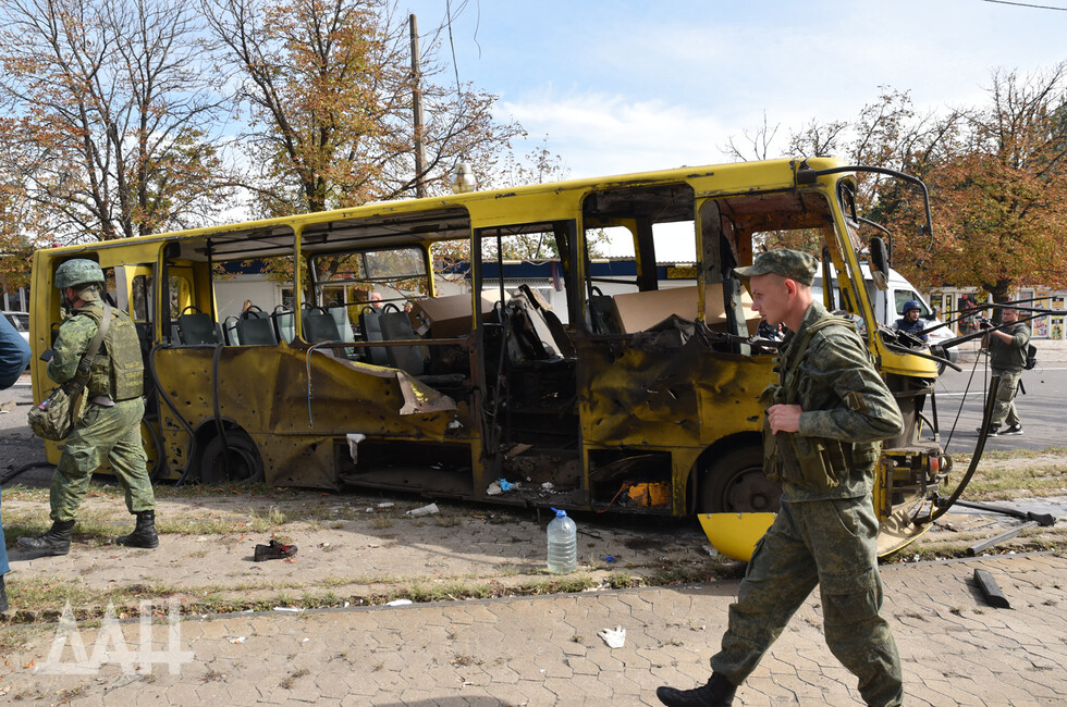

A few marks visible on the front above the blown-out windshield, at least one on the back and lower - all seemingly exit points of frags passing through the bus.  quite a few punch-ins visible with a crumpling blast wave and fireball along the side - pattern not fully clear - several in the middle of the bus punched out the other side, around the middle of the bus. One panel on the west side was peeled outward in a separate development. All else says force in from the west, out in all other directions - as for height, 3 highest marks visible on the west side are all in the front 2/3 of the bus, and several punch-outs are seen above the windshield - as forward fragments radiate the highest, this suggests maybe it was angled towards the front = from north of west or northwest. Orlovka was named. It's 21km to the NNW. This sketch uses the compass angle from that town to explain the damage seen. Similar angles would work just as well, but this does fit the picture pretty well.

dead man down ahead of oil slick (or did the driver tumble out there?). amid a field of debris - glass, window framing and panels - extending south and east from an impact point off-frame to the left. 

A gold-colored car at far left there and a black car just to its north suffered some low frag hits (likely as parked, but maybe when driving) - pieces of shell casing found here - some pavement marks visible, but not enough to see a pattern. Impact is about here, some meters north of where the bus wound up.

Another impact in the central market area - one crater seen just NW of Central Market's dome - fatalities and injuries seen a bit north of there. To hit so close to this wall, it had to come from the north and/or west, though the direction isn't very clear - the earth absorbed most of the force. Just some windows broken, light damage, dirt spray, and debris spread into the building and to the south = from the northwest, and maybe a bit more from the north. Just like the angle from which the bus was hit.

video: shell hits where? https://twitter.com/KDima777/status/1572932282658476032

another https://twitter.com/TheHumanFund5/status/1572913598376169473

All mapped with directions and lines of control: forthcoming. For now all mapped, including the 9/18 apartment building impact just added.


Review of what these "Russian provocations" and "short rounds" did. forthcoming...

Failed crater analyst and (accidental?) apologist for UAF terrorism Ryan McBeth: "I think we can effectively rule out Ukraine randomly shelling cities" (here) But was it really random, or done by a template with some terrible logic? In the cases just examined, shells hit: An occupied public transit bus - a crowded bus stop - another bus stop (but maybe on accident) - a couple of public markets - centers of government and administration and emergency services - sites of Russian-Soviet culture and history - and all of it in a place inhabited mainly by ethnic Russians who consciously reject the new Ukraine. 
 
https://t.me/kulemzin_donetsk/8471
Donetsk Mayor Alexei Kulemzin on the 19th, after shelling that would claim 13 or even 16+ lives:
"Do not go outside unless absolutely necessary! Take care of yourself and your loved ones!" The affected route was suspended for safety. 

ВСУ чаще всего бьет по социальным объектам, рассказал мэр Донецка - РИА Новости, 03.10.2022 (ria.ru)

Mayor of Donetsk Alexey Kulemzin said that the Ukrainian side most often strikes at social facilities. "There is a lot of destruction, I repeat, the housing stock, infrastructure facilities, schools, kindergartens, hospitals, temples, social facilities are being destroyed purposefully," he said on the air of Russia 24.

And so life is made to be, in what they call "temporarily occupied Donetsk" until they accept their "liberation" by NATO's favored forces. And so it has been, with varying intensity, for over 8 years now.

To link: Monitor on Massacre Marketing: Who is Really Flattening Mariupol? (libyancivilwar.blogspot.com) - recalling the Jan. 2015 attack on markets and all of Vostochniy district, Mariupol - lines of fire pointed mainly to DPR areas, but methods and motive are 150% clear in reminding us enemy lines CAN be breached, for brief moments anyway, when there's a good reason like this. Locals terrorized, told it was the DPR they would mostly welcome - est. 70% rejected this, blamed UAF - from the DNR end, friendly, allied & blood relatedma locals held hostage were shelled, maimed, killed when they drew too near to liberating them. They pulled back under pressure after they were blamed for the massacre of dozens, then Misnk talks, etc. and they didn't get that close to taking Mariupol until this year, with Russia's much-maligned help. 

Compared to Donetsk shelling discussed here ... lines of fire aren't tricky at all - they say just what motive does. ...

Wednesday, October 5, 2022

September 19 Donetsk Attack Crater Analysis

October 5, 2022

(rough, incomplete - edits 10/6, 10/7 - updates 10/15-16)

I feel bad I haven't tried my hand at analyzing any of these ongoing attacks in the Donbas and notably in Donetsk. A terrible one occurred September 19, killing a reported 16 people at least. I had seen the heartbreaking images of people dead, a few of them after something tore off their legs or whole lower bodies ... a woman severed at the pelvis who seems to have dragged herself a bit before she expired - a severed hand left laying on the street - a heavy scrap of flesh hanging off a metal bar ... 

It seems this was one of 2+ impact scenes in Donetsk that day: teleSUR English "The Ukrainian armed forces attacked the Baku square, where the various explosive devices hit a bus stop." 13 and then 16 were reportedly killed. Only 8 fatalities are visually noted at the scene in question, which is next to a sort of square and marked as a bus stop. While another 8 could easily die in the hospital, there's a photo with the article that shows a burning van and truck in another spot not at this square, which I couldn't easily find, There's also video of stalls in a public market that are torn apart. There may be a few fatalities at these other attacks, but so far, we have a good view of just the one scene. 

Otherwise, I haven't followed the story or caught up - Skipping context like who's said just what about the incident (someone else should take this and work it in with that). But generally, as usual, the locals and the Russians blame Ukrainian forces for another terrorist attack to demoralize and kill their enemies, while Kiev denies it, either implying or explicitly stating the Russians or Donestk forces deliberately shell their own people just so they can blame Ukraine.

I and 2 others were consulted by Ayaz K on Twitter to double check some "crater analysis" work presented in a video by Ryan McBeth, claiming to absolve Ukrainian forces for this attack with forensic science. This was to help inform his article Fact Check: Ryan McBeth claims that the DPR shelled themselves in Donetsk – Telegraph. Some discussion on Twitter with he and I and Michael Kobs, and this blog post - which is evolving daily ATM - seek to inform that and everyone, as possible.

The video in question: Donetsk City 9/19/22 Attack Crater Analysis - YouTube. I'm glad I was invited and checked. I knew nothing about who that is and who cares, but over 194,000 views now, 16,000 net likes, and several positive comments from people who claim to also know their stuff, suggests it's all relevant enough to bother with. Skipping other things I could say on McBeth's method and reasoning and motives ... it seems he doesn't really understand the processes involved, and got his science wrong. That's how he decided on a firing direction that's roughly opposite of the real one. Although I'm still not a true expert, I do get it and I can help set things straight here. 

The actual crater analysis takes about a minute of his 14-minute video. He brings up a common but weird (to me) diagram from an old US Army manual and the scant supporting text. See at right. It's been shown to me by many people, most of them hacks of the Bellingcat school who don't seem to understand it any better than I do. Now I have seen this almost Batman logo shape appear with shell impacts in a dirt field. I guess that's dirt drawn. But there usually are no stakes in the images we have questions about, and a compass is no help with a video. There's often no pile of dirt but instead dead bodies and fragmentation marks on pavement, waves of smoke stains, and various things getting damaged in their unique ways. If you look at it and think about it long enough, considering what weapons would do at various angles, you can get the answer that keeps being right. 

Ryan McBeth did not do that. He noted the manual's explanation the blast effect (and thus soil or debris) moves "forward and to the sides" - NOT to the rear. And so he decided at 4:55 - "there should be "more debris on THE REAR of an impact," (emphasis his). He doesn't notice that makes no sense, but the graphic is confusing; he took a stake in the middle as the impact crater, and pointed to the actual impact point behind it as "the rear." Dirt seems piled up to a point behind the crater-stake, but how and why? I suggest that's just the point of their triangle, the start of spread forward and to the sides FROM the point where shit was blowing up - not from a point a bit ahead of that. 

To clarify: I think his arrow points to the unseen crater or point of impact. The rear of it would be above this arrow, and there's nothing there. The "stake" in the middle is just that. I don't know why they seem to have put in a black hole. That's confusing.

Next, he mistook some debris from the wall to the left - that must have deflected back to land right in front of the crater - as debris blown forward from the crater. I'm pretty sure there were no bricks, nor an entire window frame embedded in the pavement. But McBeth sees these things a few inches from the crater, ...

Add 10/6: That's fun enough to just leave, but I assume he meant the broken asphalt piled up at the crater's south edge, tucked partly underneath that window frame. I marked this orange below. It seems to be a valid indicator. End 10/6.

So he decides ... that's the rear. "The arrow of debris" - an illogical arrow he just drew between the crater and the biggest visible stuff - "points south," so the rocket came from the south before blowing this stuff slightly backwards. 

Then he took nothing in particular that was on the perpendicular to that, called it "side splatter," and drew 2 arrows to show where there should be something but wasn't. He even showed these first as if it meant anything, before showing how it proves a southern origin. South is where is where his illogic wants to point. We can't be certain why that is. It's one of several directions that tends to implicate DPR or Russian forces (below: from ISW map 9/19). 

He also notes that windows to the north were broken because the blast moved "forward" - which it would do, and a bit less in all other directions - and he decided that forward was to the north. And then he mentions how glass across the street was broken as well - because the blast moved to the north and to the south? 

And so he decides the shell came from the south, "behind DPR lines." Having dropped that "truth bomb," he then shrugs like Atlas in dramatic silence and sips some water before continuing to explain why that only makes sense. He doesn't suggest the separatists attacked their own on purpose, as some will have decided. Rather, he concludes they meant to hit Ukrainian forces further north. So it was an accident - or at least 2 of them, considering the multiple strike points.  He goes on and on about the kind of shell the DPR guys probably used, where to the south they fired from and why, and what went so (tragically) wrong. 

But Skipping all that, I need to show why his central analysis underpinning all that is unsound. He has a ton of fans who've said he's right, but I think they're all wrong, and I can only guess just why. We now go to the visuals, and we can move quickly on text.

Cameras Not Lying, but Needing Some Translation

Scene geolocation: McBeth did the work, and it seems sound. A few possible issues probably resolve like he says; I've seen the same with things looking different from space, or street-level views in Google Maps being many years old, missing later changes. Location: on Shaposhnikova St at Bohdana Khmel'nyts'koho Ave, in the Kuibyshivs'kyi district of Donetsk - coordinates 48.0101689, 37.7699298. The marked-up wall is of the shop on this southeast corner, with impact crater just a bit northwest of that, in the street near the curb's corner. It seems the opposite corner to the west was the bus stop, where I guess people were gathered waiting for the next ride.

Body geolocation: Eight fatalities all near the crater, and mostly just north of it. Again, McBeth did the work, and it seems sound. All mapped on an earlier image from Google Earth. Body placement was just copied over, and a bit approximate.


Looking to the SW corner shop, awning and windows gone from both sides, and the clearly visible crater at the soldier's feet, plus dead bodies not terribly visible:

When you don't have that army manual, some triangular dirt splash or even "stakes," just fragmentation marks and smoke stains on pavement and wall, and variable bodily injuries, what do you do? Consider it all together to see what provides the best single explanation.

Pavement Markings

Michael Kobs used an existing view for this analysis. I'm still not sure that's quite it - marks are clear to the right, not so much at the bottom or on the left. To get: clearer view of an angle like this, maybe after debris cleanup.  

That's a splash/rose/sunburst pattern on pavement. In most impacts, it will be like below - an arc of intense marks less than 180 degrees - from the underside closest to the pavement - the middle of the arc and often the longest and sharpest line is the one that best points back to the firing position. The next image helps show why - the fragments radiating from the back hit the pavement at very close range and after very little spreading, making marks that sometimes blur into etched lines. Along the sides the impacts may be more glancing, then further out, none at all. And it all depends on impact angle; if it comes straight down, there will probably be no pavement marks in any direction - it will all go into walls, people, etc.


Another crater view - Eva K. Bartlett photo. She blocked me years ago, probably for saying "Assad regime" as shorthand or something like that. So I can't ask directly, but if anyone there can get us (or has gotten us) a clear view of this pattern before it's gone, that will help with the record.

Enhanced, likely frag marks painted red, maybe missing some and including some other things, and getting less sure what is or isn't right in the middle. I see here and in the wall marks 2+ frag sizes - tiny ones punch in and burn the pavement? They seem to get bigger and heaver to the right, chipping away pavement? That seemed like the back direction I was looking for, but it didn't fit the rest of the damage so well. not sure from these views, but this might be more what we're calling side-spray. That would be similar to what McBride labeled, and what he meant, and he was right ... but he had it backwards. All told with the opposite wall also marked ... 


Here may be where and how the lowest fragments, among those sent backwards, impacted the ground - concentrically from the middle: the lowest fragments dug the back side of this crater - the next ones up removed the pavement a ways out - the next layers up marked the pavement heavily for a span - the next ones more lightly and loosely. 

The pattern looks odd to me - maybe foreshortened so we hardly see back spray, and instead see more to the sides, because the munition came in abnormally horizontal, following an unusually long-range flight. Or maybe it's because that is just the rose spray behind impact, and it points back to the northwest, but I added too many dots in other areas. This analysis should not be taken as gospel, but as a point of reference for further consideration.  

Back to the shell - Fragments facing down will hit the pavement quickly, the middle ones most directly, and the outer ones up to the sides at more oblique angles. Those packed in the side and forward will all radiate above ground, increasingly high as one looks in the forward direction. 

Any wall to the side of such an angled disc of damage may be marked with fragments in a sloping line that's roughly perpendicular to the incoming munition's vertical flight path. If it came straight down, its damage band would be horizontal.  With such an angled pattern, up = the forward direction of flight. Add 10/7: Michael Kobs modeled the "doughnut" of fragments to help illustrate why up = forward. I labeled this frame at right. 

See the opposite wall above, where the burning frags and the detonation fireball hit the wall, sloping up in a direction that is SOUTH. Therefore, the projectile came at least partly from the north. Above: two possible estimates - I drew the red one first, but the magenta one looks better.

It probably won't be from due north parallel with the wall, but it's far from perpendicular into the wall. Consider that we don't see a line, really, but an arc of marks that would roll off to horizontal at the front, while angling more on the sides. This is clearly more side than front. That angle would seem to be a bit into the wall, not away from it. So this is probably some kind of northwest, but one leaning well to the north aspect. But it could be from due north, and come to think of it, it could be from a tiny bit east of that as well, but even then, simple "north" is the best way to put that option.

Next: the nature and pattern of casualties tells the same story. 

Out in front and to the sides at mid-distance, people would face a scattered but body-wide danger over a decent span - they might be hit in the head, torso, or lower body, or all of them, depending. Closer in, the frags will have spread out less, making intense machine-gun-like contact, that tears off body parts, more likely. 

Ahead of the blast, it's more likely the head that will suffer, but far enough out, the fragments might angle totally above people well before they would fall short of them. add 10/7: crude sketch. 

Behind the blast: those quite near might have fragments passing just above the ground and intensely, puncturing and even shredding away feet, legs, and whole lower bodies, besides more scattered hits to the middle and upper body. Further behind, the intense frags are used up, and the danger zone of lighter ones might be horizontal for a while, or might angle down into the ground, besides having scattered out wider. Severe injuries here remain possible, but probably not dismembering or fatal ones.  

Add 10/7: the mapping of bodies above is just approximate, based on a quick copy of McBeth's mapping. I MIGHT have a closer look at who was injured where on their body and where on the map more exactly, to improve the usefulness of these clues. But so far I haven't. End 10/7

Ahead, to the south, and along the side: intact people with legs have fallen from hits to ... mostly unclear to me. I saw one that was hit in the belly and lower leg, at least. Likely the head too, causing him to die like that.


Behind, to the north - low fragments hitting a pillar - the expansive and high-rising detonation fireball wrapped around the pillar above that, but not very far above. This isn't forward. people with legs and lower bodies torn away, a stray shoe, scraps of flesh, river of blood, all within a few meters of the crater, some probably after crawling a bit or being moved - most likely further away than they had been. 

Further back: no one who fell and died and was left there, anyway. As McBeth noted, the severed hand was near the furthest body out on the west side of this area. A few others may have been left with dangling limbs, massive bleeding, punctured lungs, and other fatal problems, but they weren't just mowed down like this. This view shows where they fell, vs. the only fragmentation marks I can mark out on this pillar. It's marked to about halfway up, not to the top. At the bottom are some of the heavier frags. Seen closer, there will be more marks than this, but this is a low band of marks compared to the others, here a bit north and east of the impact.


And this too fits the overall, multi-faceted picture of a munition - be it small rocket or mortar shell or whatever - that was fired from the north or the NNW - the one narrow range of directions in which Ukrainian forces were still operating within a 10km radius. They've always terrorized the people of Donetsk and denied it, blaming the separatists or the Russians for shelling their own. Thay also could miss their targets - 2 or 3 times - OR they could more logically have done it intentionally. And while the forensics here don't point exclusively to them, they sure as heck don't point exactly away from them like McBeth strangely concluded.

McBeth Response:

(added 10/6) I'm hoping for some non-hack response, including to my aggressive tone. I'd prefer that over a weaselly evasion with that tone as an excuse. It's difficult to admit you're wrong, but still it's important. I'm ready to do that myself, it I can actually see how I was wrong on any point here. 

But ... (later) it seems he's blocked Michael, has muted or is ignoring me and Ayaz. He had three things to say to or about us before that. To Ayaz: "Please read Army FM 6-50" (the manual). Like that can explain what went wrong in his brain. To Michael, who mentioned a Grad rocket or a mortar shell as examples of what might have been used, he said: "You really need to think about this. Why would you launch one grad rocket? Gran Rockets are launched in multiple waves. This could not have been a mortar round because A 120 mm mortar would’ve only originated from inside DPR lines. This was a short round, unintentional but tragic." It came from behind DPR lines, he thinks. But still, it couldn't be a 120mm mortar shell. I don't have an opinion what it was except fired from the north-NW. Ayaz and I both asked him for comment on our findings, but he never replied. Instead,  he mused in a tweet "It’s pretty cool when people are so afraid of you they say you are wrong in a “fact check.”" People do that when they think you're wrong, not when they're afraid of you. Afraid people will try not to provoke you, like with a fact-check. Or they'll ignore, mute and block you. Ayaz replied "Yea the person who was asking for answers before writing this article and didn't get a clear answer is totally the afraid one." Gaslighty McWheelspinner, KJohnson,  came to McBride's aid, explaining to me "He is ignoring you. His analysis was far better than yours. Harassing him to change his opinion & take down his video is pure desperation on your part." As I replied "I was giving him a chance to not be a lying hack like you. And giving him extra chance too. WAS. Past tense. He's just a lying hack who covers for mass murder on political lines just like you, Bellingcat, a bunch of corrupt governments, and millions of other soulless people. Sad." Apparently, anyways.

Add 10/16: was I too harsh? A quick review of McBeth's "investigation": "I believe that the dead bodies in the video are #Russian #propaganda" (here) in part because "the clothes of the dead don't match up with the weather that day & mortar rounds don't cut people in half like that." (here with 1st video). in a full thread with the later video (here) he cites an ancient lithograph that I for one can't decipher, and so he decides "debris are highest at the rear of the round," then drew an arrow pointing south where there's a bit more piled debris, pointed out how it points south, etc. "So in summary, I think this was an accident, but it was almost certainly caused by Russia or the DPR." Because it came from the south. But also for good measure because "I think we can effectively rule out Ukraine randomly shelling cities" - even if his analysis did get it backwards. (here)

Updates October 15: 

I finally got a grip on the "splash" pattern that seemed to point west while other clues seemed to point more north. It has different parts I can't fully explain, but the overall shape seems to fit all the more visible bits into a logical whole that includes some invisible parts. The left/north side (bottom here) was unclear compared to the right. This view, color-enhanced, revealed that besides the smoke stains across the area, a different, almost greenish shade appears, in a shape which I traced in pink. Whatever caused that, it fits well for the front edge of the splash pattern, encompassing the few visible marks in the pavement here (which I popped out in red as I think I see them), and it gives them a logical shape. The marks on the right were already visible, and they mirror that shape. The (pink) forward edge isn't visible here under the window frame, but I traced it roughly to match. Quite roughly. Ejecta in orange - piled rubble still seem off center to the right/south, but there's some on the left and more hidden under stuff.  I'd bet it's a bit right of center all told, but pretty symmetrical.

Note: that sharpens a video blur, giving everything a melted-in-tar look. But I think the asphalt also may have been extra soft, leading to more rounded, less visible impacts than usual. 

Using that with other views I tried to trace the same basic pattern and use it to trace the trajectory. From the crater roughly to the former corner (vertical line here), where the wall bends to a 45. See 2011 street view below for comparison. I think the low wall to the right is intact, just defaced, punched through, and rounded, and lost the window frame it was holding up. To the left, the wall looks fairly intact as well, but detached at the bottom and pushed back? Those panes used to meet, but now one seems to hide behind the other. Or is that just the corner and my eyes trick me? 

Crater placement: in the images above, I marked a grid point in yellow-green, with a line west from where the 45 angled wall ends, and another line running north, set the car's width from the sidewalk. Note how they intersect about at the window frame's corner. The crater is just a bit east and 1 or 2 bits north of that grid point. The trajectory is from there to where the 45 wall starts. 


This would mean I was wrong about damage angling up on the (main) wall. I connected too many dots on irrelevant lines. Ahead of the blast at that corner, the band of damage should be highest and level, and then actually sloping down to the right. I was just noticing marks fall pretty top to bottom all across, and thus the pattern is mostly unreadable. However, the lower marks on the pillar to the north are still relevant, and would fit this angle about the same way, being more on the side of the arc. So the bands I drew above from the low-marked column - where 2-3 died in the canopy area - are still pretty applicable, but those closest to the impacted corner should suffer more widespread injury, being ahead of the blast. Any such might be blown into the shop where we don't see them. 

I'd expect the legs-gone zone behind the blast to be north of the doorway, in the canopy area, out into the street, and at the opposite corner, mainly around the arc in purple at right. There would be roughly 0 people standing in the street, one to the west but a ways out, where frags would angle higher and wider - no longer likely to sever parts. Around the covered area and pillars north of the doors, any person getting their legs torn off will also be moved with the same force, maybe winding up under the canopy or up to the doors like we see, maybe after deflecting off the pillar or the roast chicken booth (dark green).

The line I drew to firing spot measures 304° on the compass. That's an estimate, but a good one. I'd venture it's actually a hair lower, and to give some room for further error, I'll suggest 303° +/- 3 degrees, or a trajectory of 120-126°.   

Finally a bit on who has said what: Donetsk Mayor Alexei Kulemzin on Telegram: (translated) 
"at 12:15 and 12:23 a total of 9 shells of 155 mm caliber were fired in the direction of the Kuibyshev district ... from n. n. Netaylovo."

Google maps has this town as Netailove, almost exactly 20km from this shell impact, at bearing 302 to the middle of town. My 303 reading says the same, as does 304 mapped here, specifying northern half or outskirts are more likely included in the line of fire. I wouldn't say if it originated inside the town, closer on the line (SE), or further out (NW) from the strike. But it will be on that line or very close to it.

I won't have a lot to say on how the scene lines up for a 155mm shell, except to note that McBeth doubted it, and while his judgment seems to have no value, maybe he's right anyway and a different kind of shell was fired from around Netailove. I won't have a lot to say on what fired the shell and how the range compares, or who exactly was operating there. But whoever it was, they might realize the shells they fired at 12:15 and 12:23 killed at least 13 innocent civilians at a bust stop, maybe 16 or more, besides terribly injuring many others. No one's holding them to account, and they probably cheer the fact their work that day sowed more terror than usual. The mayor said "Do not go outside unless absolutely necessary! Take care of yourself and your loved ones!" The targeted bus route was suspended for safety. That's the idea. Daily life needs to be made unlivable - and sporadically ended - for the people of Donetsk, as long as they resist their "liberation" from a "temporary Russian occupation." It's been over 8 years so far. 

Sunday, October 2, 2022

Maxar and CNN Turn a Blind Eye to August Shelling of ZNPP

Ukraine's Systematic Shelling of ZNPP: Maxar and CNN Turn a Blind Eye to August Shelling

October 2, 2022

Friday, August 19: Russian president Vladimir Putin “stressed that the systematic shelling by the Ukrainian military of the territory of the Zaporizhzhia nuclear power plant creates the danger of a large-scale catastrophe that could lead to radiation contamination of vast territories.” (AFP via Times of Israel) As explained below, this came after at least seven shelling attacks on the Russian-occupied plant, four of them coming in the week August 11-17, 

CNN would feel compelled to reply later the same day, denying the attacks with a 5-author report that found:

"There are no signs of "systemic shelling" at the Zaporizhzhia nuclear power plant, new satellite images from Maxar Technologies show. This counters Friday's claims by Russian President Vladimir Putin that the Ukrainian military was conducting repeated military strikes at the plant."

"The latest satellite images from Maxar Technologies were taken Friday morning. CNN has analyzed a number of satellite images of the nuclear power plant complex located in Enerhodar, Ukraine, and it shows little to no change in damage or destruction since July 19, when a Ukrainian military strike on three tents just under 1,000 feet from one of the nuclear reactors."

In a CNN OurFront video report on this story (New satellite images debunk Putin's claim about nuclear plant - YouTube), reporter Sam Kiley came on to explain how the latest views show there was "no significant increase in the damage to Russian locations, Russian-held locations around that nuclear power station" over the last month. 

OutFront host Erin Burnett added funny faces and sounds of exasperation to the absurd claim they were forced to debunk: "Now ... Vladimir Putin has claimed that the Ukrainian military was shelling their own plant, in the middle of their own country." Specifically, they were said to attack Russian forces in their plant and country, but still ... The Ukrainian people rely on energy from the ZNPP, and would suffer badly from any meltdown this shelling might cause, so why would their leaders risk it?

First, the plant is more in the middle of areas Russia has annexed, or is now considering annexing. Likely fallout would affect the plant, ruining it, and would contaminate all south and east of it: Crimea, Melitopol, Mariupol, Donetsk, and well into the Rostov area of southwestern Russia itself, according to some models, like this one from late August. It's terrible, but not at all absurd to think the Ukrainians would risk such a devastating blow to THEIR ENEMIES. 

Here's another one from back in March showing Crimea missed but Mariupol, southern Russia and Kazakhstan getting hit:

Or the fallout might drift more into Europe. It was "feared" that "Russia is preparing the ground to accuse Ukraine of attacking the ZNPP." The accusations could come and be truthful, but either way, US Rep. Adam Kinzinger said, "Any leak will kill people in NATO countries, this is an automatic inclusion of [NATO article] 5," the mutual defense clause. (UP via Yahoo News) This seems quite debatable, but still, tricking NATO at large into direct conflict with their Russian enemies by causing a radiation leak would be in Kiev's military interest, not against it. 

And anyway, it's not "their plant" at the moment, but a Russian-occupied one. That's the whole point. It's Volodomyr Zelenskiy who effectively claims the Russians are shelling their own plant in the middle of their own country. He says they did this after turning it into their own military base and attacking Ukrainian civilians from it. Maddeningly, this makes retaliation "impossible" as many say - unless the Russians do it to themselves, over and over. And Zelenskiy says they do that. 

But then again, 5 days before Putin's comments, on August 14, Zelenskiy already had enough of Russia' ""constant provocations" by firing on the plant" while also firing from it. He promised: "Every Russian soldier who either shoots at the plant, or shoots under the cover of the plant, must understand that he is becoming a special target for our intelligence, for our special services, for our army." (BBC Aug. 14) He didn't specify they would attack anyone WHILE they were at the plant, but that's the widespread reading: The Guardian had Ukraine will target Russian soldiers at Zaporizhzhia nuclear plant, says Zelenskiy

CNN's Burnett understood that "both sides" were by then "making accusations about military actions around the plant." Ukraine's claims were also of systematic shelling ("constant provocations"). Both sides agreed on the repeat nature of it. But she assured us we could know Putin was lying because - as viewed from satellites in orbit - there were "no signs of systematic shelling - at all." That would make Zelenskiy a liar as well, but that didn't seem to matter at the moment. 

Start: "July 19"

What CNN's team noted was a lack of changes "since July 19." If any images from then were used for comparison, they are not shown in the video or with the report. If they are publicly available to check, I haven't found them yet. 

CNN's people wound up looking at this span because Putin chose to speak one month after "a Ukrainian military strike on three tents just under 1,000 feet from one of the nuclear reactors." That was on July 19, as CNN gives it, although everyone else cites the 20th. As a later CNN report's attached timeline says, on the 19th, "A Ukrainian drone attack targets a Russian tent complex inside the plant’s main security exclusion zone, including a parked BM-21 ‘Grad’ rocket launcher. The attack led to a fire but did not damage the reactors or fuel storage areas." This wasn't "systematic," they want you to know. It was a onetime thing, and nicely limited in scope - not at all what Mr. Putin was claiming. 

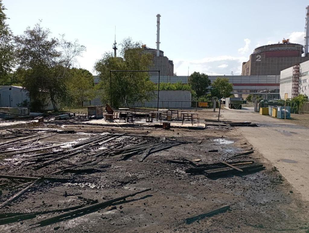
This incident is covered somewhat in a previous post here. Adding in this post some photos of the aftermath and drone remnants from Russia's Mission in Vienna on Twitter. Above: aftermath at the encampment.  See also a July 22 UAF video that shows one drone strike by the tents and no fires started (there were more strikes unseen) and a hit to the pavement next to the BM21 among the outer spray pools. 

The area of burned tents is plainly visible in satellite views. Sources at the time bragged of three soldiers killed and 12 injured, Claims and images agree Polish-made "Warmate" kamikaze drones were used. At right, the spray pools where the BM21 was hit, with the drone's propellor and motor next to damaged concrete.

That's one undeniable attack by Ukraine, within the plant's security perimeter, near special building 1 (waste storage), the spray pools, and - at least on Russian MoD maps - it was quite near "radioactive isotope storage." With this, CNN couldn't entirely deny such strikes, just that they were repeated, systematic ones. It's after this they checked and refused to see the signs that the attacks continued. 

August 20 - 29: Zero to A Lot in Ten Days?

CNN shows this detailed satellite view of the ZNPP as it appeared mid-day on August 19 (tuned roughly 45 degrees clockwise from true north):

This was released by Maxar that day (on Twitter), along with a more detailed view of the six reactors.  "New #satellite images collected this morning, August 19, 2022, at 11:33 AM local time, of the #Zaporizhzhia nuclear power plant facility in Enerhodar, #Ukraine. No significant signs of recent shelling or damage is seen in or around the nuclear plant." There are certainly no buildings visibly collapsed, or anything of that sort. But as we'll see, that doesn't mean so much. 

After this weak showing, it seems Ukraine was egged on to up the scale of their "Russian shelling." It turned more intense and closer to the reactors starting the next day (the 20th), and it stayed like that over the next 8 days; see the 14 red squares on the map image below. 

Attacks of August 25-28 left marks to the roof of special building 1 visible in a morning view of August 29. A Warmate drone was shot down over the same roof on the 28th, and another on the 29th. Maxar was willing to show this damage, but without mentioning it, and this time without comparing it to any Russian claims. Rotated crop on the damage at right.  On Twitter they would say "New #satelliteimagery from this morning, August 29, 2022, of the #Zaporizhzhia nuclear power plant in Enerhodar, #Ukraine. A group of inspectors from the International Atomic Energy Agency (#IAEA) prepare to visit the facility this week." From this, it's not clear who did it - maybe someone who didn't want inspectors there. That better described Kiev than Moscow.

These images were taken by both sides as proof of systematic shelling by Ukraine or Russia, depending what they already suspected. If it's artillery fire, it came from the north-northeast. Otherwise, it might be done by the Warmate drones being shot down over this same roof. Both possibilities tend to implicate Kiev.

CNN didn't weigh in clearly regarding the new images, but in the meantime, on August 25 they noted an exodus of plant staff over rising dangers. As worker Elena said, “everything explodes there.” CNN heard that "Three Ukrainian plant workers have been killed by the Russian military since March by beating or being shelled." So the shelling now seemed real, deadly, and Russian.  A report from the 27th noted the power supply to the plant was cut off - "the government here says - by Russian shelling." By September 2 CNN was impressed by "just how narrowly Zaporizhzhia NPP has avoided a nuclear disaster." after all that disputed, probably Russian shelling that had snuck into their reports - especially when they already decided there was no such thing for most of that time. 

Attacks They Didn't See

Again, I haven't seen the July comparison images, but to the extent there's no change visible by August 19, that's secondary to what it misses; real and photographed damage from attacks that did occur, on multiple occasions in those 31 days. Attacks on the plant were reported on at least six days in that time, sometimes two in a day. Three of these were in the core area and have visual evidence I included in the graphic below. Yellow boxes show the July 20 attack CNN acknowledges, and the many red squares are damage that didn't yet exist, but that started the day after CNN's denial. Yellow-green, green, and blue mark these intervening attacks on August 6, 11, and 17.

These are placed here on a later and better view of the 29th, but I checked for the few visible signs to make sure they appear on the earlier view. I show some results below, and the full image is included above to check by. Some squares on this map with cross bars are not geolocated, but mapped approximately, as given on this small-sized Russian Defense Ministry map that's correct where I can verify it. Source: https://twitter.com/mission_rf/status/1560570480087678977 

Note the list of 8 incidents at the bottom of the image. These entries are noted below for each event, "as listed." Also linked from this tweet: some details on the incidents of Aug. 11 and 14 included with those entries. 

The damage shown here actually existed, but it's probably too small-scale to appear at even in high-quality satellite views. Still, for good measure, we'll check on each one to see what we can. In each of the 3 cases with adequate visuals to say, the evidence points to artillery fire from the Ukrainian-occupied north bank of the Dnieper River.

August 5: IAEA: "the ZNPP was targeted in shelling resulting in several explosions near the electrical switchboard of a 750 kV external power supply line that caused the shutdown of the electrical power transformer and two backup transformers. One reactor unit was affected. The emergency protection system of the affected unit was triggered, diesel generators were set in operation to ensure the power supply for this unit. This unit remains disconnected from the grid." And "renewed shelling hit the area of the ZNPP’s nitrogen-oxygen station. Firefighters quickly extinguished the fire; however, the station required repairs." 

Zelenskiy: "Today, the occupiers created another extremely risky situation for everyone in Europe – they fired on the Zaporizhzhia Nuclear Power Plant, twice in one day." He called for tough sanctions on Russia's entire nuclear industry. (Censor.net)

As listed above, 20 152mm shells were used in a UAF attack. As mapped: "open switchgear" just south of the training center, and just off-frame of my map above. Video shows brushfires at the electric station south of the plant. Visibility from space in the 7-19 view: unclear - I've looked at no clear visuals of impact sites.

August 6, evening: An article at EBC Tech, August 7: "The director general of the International Atomic Energy Agency (IAEA) Rafael Grossi, said that he was “extremely concerned about yesterday’s shelling of Europe’s largest nuclear power plant,"" an act that “highlights the very real danger of a nuclear catastrophe" with global implications.  Grossi called on “all parties” to exercise restraint, and he again insisted on a visit by the IAEA investigative mission to the besieged site." Their September report (PDF) would list this attack twice, on the 6th and the 7th, with slightly different details (e.g. one has an employee injured, and the other specifies a security guard was injured).

Zelenskiy bemoanded "the threat that Russia created by striking at the ZNPP." Kiev-linked plant managers Energoatom would report "the Russian Federation carried out another missile attack ...  Apparently, they aimed specifically at the spent nuclear fuel containers" Russian sources claimed that "at night" on the 6th, Ukrainian forces "launched a strike using a 220-mm Uragan MLRS rocket" towards the ZNPP and that it had "managed to open up and release fragmentation submunitions." As listed: 1 rocket Uragan MLRS in cassette was used in a UAF attack." 

Location: As mapped, next to spent fuel storage. Detailed verification of position here, citing photos and videos mainly released by Russian-linked sources.

Impact analysis: The trench dug by the spent shell runs roughly NW-SE, with soil dispersion mainly to the southeast. That means the rocket came in from the northwest. The tube bent forward and a bit to the side when it stopped, so it can appear like it came from the east and ejected soil almost backwards from how it should, but that makes no sense. It also did not "turn 180 degrees" before impacting, as people love to joke, and I don't think anyone even claimed that. It was a straw-man. 

It remain as debatable as anything, but that's my take.

The embedded rocket tube is some 40 meters south of the gate into the dry spent fuel storage site.  Cluster munitions it released impacted in 7 spots that I've seen and placed - all to the north. Some minor damage within the storage site was also shown, with fragmentation marks visible on the container in the front row, south side (see at right - better view and context needed). The date of that image and connection to this attack is unclear, but the rest are shown as part of the same event. The pattern of impacts is incomplete, but it might suggest the rocket came more from the north than I had estimated.

Visibility from space in the 7-19 view: there is a faintly visible brown patch between the closer 2 of 3 outer trees (red circle), and some of the bomblet impacts might even appear (just to the left of each red dot - magenta inside the site for "maybe"). 

If you were looking for that confirmation, you'd see that and wonder, and then you might ask "why am I bothering? Are those videos and photos all fake?" Of course not. This rocket tube was really there since these views on August 7 up to at least the IAEA team's visit in September.

August 11: IAEA: "On 11 August, a new episode of shelling occurred, damaging one radiation monitoring detector at the plant’s fire station (approximately 500 m from the industrial site)." As listed with the map above: 4 152mm shells and a "Hellfire" rocket were used in another provocation by unaccountable Ukrainian forces. 

An Aug. 16 tweet gives photos and a map and a VK link to details: "During the shelling of ZNPP on August 11 by the units of the 44th artillery brigade of the armed forces of Ukraine from the side of the town of Nikopol, the auxiliary thermal power plant and the equipment of the spray ponds of the nuclear reactors cooling system were partially damaged. Some infrastructure facilities of ZNPP hydroshop were destroyed"

Location: across from reactor 1, where another photo (below) shows better this building lies between a gated road and a lower sort of shed. This is the building's north face, with the photo at right taken in the afternoon, facing west. 

Other impacts are mapped nearby, noted as near "radioactive isotopes storage." And "according to updated information, on August 12 as a result of a direct hit by an artillery shell of the AFU in the security zone perimeter cable tray, the technical security system was disabled and remains inoperable." But I only have full-sized view for the one spot. A small view is included of another scene across from reactor 1, which I've seen in fuller size, but passed by and cannot relocate now. 

Impact analysis: serious damage to brick wall on the western 1/3 of this facade. The middle 1/3 was some lighter paneling that was knocked out much easier. Viewed from the outside, rounded damage on the left vs. total removal on the right suggests it came from the right = west. Seen from inside, the rebar mesh deformed to the east says the same. But a wall section blown out directly to the right (close to the outer wall and not much to the south or right here) seems to make the most sense coming in neither left nor right but perpendicular. A large toppled object is unclear - I don't know where it used to be.

Back outside: the smoke stains from the detonation fireball are mainly just above the impact center, and a bit to the left, but not to the right. All this says the shell was fired from the north or perpendicular to this wall, and probably a bit from the west of that. Or, as it turns out with the plant's overall 21-degree rotation, it most likely from about due north (shown at right), or even a bit NNE. That comes from the Marganets area.

Visibility from space in the 7-19 view: impacted north wall in shadow, not at all evident here, or probably in any view - rubble on ground may be faintly visible or cleaned up in the 7-19 view. Invisible, yet real.

August 14, as listed: 10 155mm shells of M777 howitzer (USA) and 2 guided munitions were used in a UAF attack - In the evening of August 14, as a result of another shelling by the armed forces of Ukraine (AFU), an open switchgear of 750 kV was damaged. There are malfunctions in the central control panel for the distribution of electricity at ZNPP. The extent and character of damage is being specified." Visibility from space: unclear (no images or clear location).

August 15, as listed: 30 152 mm shells were used in a UAF attack. No further details. Visibility from space: also unclear.

August 17, as listed: 1 Polish drone and 11 152 mm shells were used in a UAF attack. RU mission in Vienna shared photos on the 18th, apparently from this attack: "Ukrainian armed formations continue to shell Zaporozhskaya nuclear power plant, using Western-made shells. US Manufacturer's data is visible on the photo - @EaglePicher That is how Kiev regime and its Western supervisors threaten nuclear security of the largest NPP in Europe" There are three photos of an intact shell, and one of some ill-defined damage in a vague spot.

Location: view faces south to training center - a mangled fence, perhaps on an earthen mound, disrupted, with the main crater-impact off frame. Past the fence is an empty span, then a higher concrete wall and fence - probably how the perimeter fences look at the red dot on the Russian MoD map, 50m from radioactive isotope storage. 

Visibility from space in the 7-19 view: disruption of fence-ridge almost at the red dot is plainly visible, along with and a crater on the other side of the far fence, as shown at right. The building to the left also may show some burning at the north end.

Impact analysis: the crater's soil dispersion is unclear here, but seems more to the southeast in the 8/29 view. The fence we see is blown outward and maybe a bit to the right, which is to the east or southeast. In both senses, fire from the northwest is suggested - yet again - but not all that clearly.

That makes four attacks in a single week. Also on August 17, Russian-linked sources address the reported detention of some plant employees. Local administration head Vladimir Rogov: "Details of the detention of employees of the Zaporozhye NPP - artillery spotters of the Armed Forces of Ukraine. Today in Energodar, law enforcement officers detained two Ukrainian artillery spotters. They helped to strike at the territory of the nuclear power plant and the city. One of the detainees, Oleg Morochkovsky, worked as a security guard at a 750 kV open switchgear (ORU-750). The second is engineer Alexei Danilov."

Later Attacks You Can Just Barely See

One of the more dramatic attacks came just too late for CNN to see, and just after the attackers were egged on by their denials. IAEA report: "On 20 and 21 August, shelling damaged ZNPP infrastructure, including transitional galleries used by ZNPP staff to access the power units (overpass), as well as laboratory and chemical facilities." Russia's Mission in Vienna: "Another shelling took place on August 20. One artillery shell exploded in the vicinity of Special building No.1 and three shells near Laboratory and household building and Special building No.2" Photographs and an overview map included.

Visibility from space: faintly visible as dirt patches in the grass appear for the two with big photos, and perhaps some dark pixels for the other two spots - I think - in Maxar's 8/29 view (inexact geolocation) - graphic comparing 8/19 view (white) for each spot, to show how little even these sizeable changes come through from Earth orbit, even in high-quality images like this.  


The photos aren't terribly clear, but seem to show soil dispersion towards the camera and a bit to the left, meaning fire from the west-northwest, probably closer to Nikopol than usual.

Some damage at the pant is plainly visible from the space - the roof tears on Special Building 1, for example. And there is a dark, angled smudge right next to reactor block 6, consistent with fire from near Marganets to the NNW, that appears between August 19 and 29, and is inspected by the IAEA as a relevant impact. It's near 2 other shell impacts reported and shown on the 27th, said to be fired from near Marganets and with a consistent suggested trajectories. One hit the special building, and the other damaged water pipes of the cooling system (see here and here). 

But these other impacts lie in the shadows and don't clearly appear from space. Over and over, very significant artillery impacts fail to come through at all. That should be no surprise. 

In choosing to view it this way, from OUTER SPACE, Maxar and CNN opted to effectively squint the evidence away. The only valid point they could raise is none of these alleged Ukrainian attacks was massive enough to be plainly visible from space (except for the one on the 17th, but they didn't really look). Instead, they reported their voluntary vision impairment like it meant something - "little to nothing" was actually happening on the ground, among the stored radioactive materials, pipes and devices necessary to avoiding nuclear catastrophe. The flippancy of this report on such a serious subject is essentially criminal.

Now, is it "Systematic"? 

CNN suggested the shelling at Zaporizhzhia Nuclear Power Plant was exaggerated or perhaps made-up by the Russians. But where you can actually see it, it seems real. Weapons were fired distressingly close to sensitive areas, before and since, several times destabilizing the situation so corrective measures were needed. Furthermore, we can see these reckless attacks are launched from the north, where Ukrainian forces are, and/or are done with Western munitions and Polish drones Ukraine uses. 

And in the end, as President Zelenskiy says, this "constant provocation" ... "only mobilises even more global efforts to confront terror," of course meaning Russia. We saw his response to the August 5 shelling (or we see a bit of it at right), urging some firm response to Russia's shelling. The next day, Russia was caught again "striking at the ZNPP." Ukraine's local head of Military Administration, Alexander Starukh, declared “the situation requires a real response, not an expression of concern” like the IAEA had issued. (EBC Tech)

Kiev had apparently just launched cluster bombs from the northwest, with the bomblets landing around the spent fuel storage site, perhaps damaging some containers, and reportedly injuring a security guard. To that illogical "Russian shelling" of the Russian-occupied plant, the only response Kiev's supermacists wanted to see was something "real." Direct, international military action against Russia captures the spirit best, but Zelenskiy was pedaling new and "tough" sanctions to cripple Russia's nuclear industry, adding to the measures meant to bring its people finally to their knees.

I think I can make out a system at work behind this. Enabled by foreign governments and others, including in Western intelligence and the mainstream media, the Armed Forces of Ukraine continue at the ZNPP their system of shelling and spinning - as they've done for years in the Donbas - so "the Russians" are always "shelling themselves." While each attack on the plant carries little immediate risk, tensions are kept high, and Russia's occupation is kept in the news, transformed from a basic fact into a constant screaming danger to the whole world, that can only end when the Russians leave the plant. 

Western leaders agree and insist Russia's presence is the "root cause" of shelling at the plant, if not the direct cause. They know it's Ukraine that keeps launching in shells, rockets, and explosive drones making it so “everything explodes there,” as worker Elena put it. They know that this will not stop until Kiev has achieved its goal, and the West wants to help reach that goal. So it continues. And if this ceaseless Ukrainian shelling causes a catastrophic meltdown along the way, well... there will be radioactive fallout for the Russian people, and then further punishments to follow.