
August 23, 2018
rough, incomplete/may be revised, etc.
last updates Sept. 8
Back in February, Adrian Kent on Twitter directed Scott Lucas of EA Worldview to my piece at The Indicter analyzing the Khan Sheikhoun chemical attack in 2017, and specifically the findings of the Un "Independent Commission of Inquiry" (CoI). I'm still not Still not sure if that's what was asked for - I had JIM and CoI and even OPCW a bit confused, but mainly they agree on the big picture of Assad blame, if not the little details like whether or not there was a breeze.
Response:
https://twitter.com/ScottLucas_EA/status/964820205242408960
With respect, this is pretty muddled and much of it is speculative. So, when I have time, I'll work through claims one-by-one, starting w wind.
He never did. (see bottom of post for more) If he or anyone else were to try it, I'd say let's skip the rest and focus on the wind. That's central, and also reasonably simple. Not that tracking down what all I've said is easy … I've explained it first and mainly here,
libyancivilwar.blogspot.com/2017/05/4-4-17-wind-direction-explainer.html
but then here, and here, and that re-done as the Indicter article, and re-packaged in a couple other places, before this post, where I'll simplify the visual core in the interest of securing some explicit challenge. This part is not very speculative at all, and I'll try to make it even less so below.
Briefly though, on all other issues: I stand by the claims in that article with one exception - the radar flight track: my mapping of what it shows is accurate, but I later noted a serious starting offset. Adjusted for this, the radar image does put the jet passing above or very near the sarin crater. Explanation of this, and on how little it does to prove the government is guilty, can be found here.
Feel free to rip on that but note - I revise my findings when it's warranted. And let's not lose sight of the crucial wind problem. Even if that jet did drop this bomb, the stuff coming out if can't just defy the laws of physics in order to complete one's preferred storyline.
I've seen disagreeing analyses, but they're all limited, and fail to really explain the overall movement the way my multi-view method does. As it appeared at the Indicter and previously, I had a clear range of directions to the northeast identified as consistent with all seen air movements. And again, this is roughly the opposite of what was reported; people killed entirely to the southwest as the wind blew the sarin plume into their homes there, from the one and only spot anyone claims sarin came from. Here's how I've been showing it:

This was never a perfect analysis, just the best one yet. There is some debate and disagreement I've encountered that, on review, is valid, and I've been re-visiting and refining the findings.
* The previous direction stands, roughly, as the direction at upper levels. It's probably a bit less to the north than this, but still well north of east.
* Closer to the ground, which matters more, the directions is harder to read, and will vary a bit from one spot to the next. In general, it seems less northerly. For now let's say it's a wind more or less to the east.
Of course the space things move trough is described as three-dimensional, having height, width, and depth. Here we'll mainly ignore height, or movement up or down (yes hot smoke rises and most other things fall - this tells us nothing). So we consider the two surface dimensions as on a map, each described by an axis, relative to the camera;
* width, or left-right movement,
* depth, or movement towards the camera or away from it.

To consider:
* Pure movement on one axis being rare, we'll usually see one of these 4 combinations to describe video-based movement, when enough information is available; left and away, left and towards, right and away, right and towards.
* If we know the angle of view (we do in all cases here), the camera-based directions can be converted to map directions.
* There isn't always enough information; left-right movement is what comes through clearly, and what we'll mainly consider. Movement in depth towards or away is harder to discern, more speculative or to be deuced secondarily by considering clearer movements as seen from other views.
We'll consider six exhibits, each from a certain line-of-sight labeled A-F, all shown here on the map relative to the plumes. the sarin impact area (blue, off-frame, just for reference) and the tel, or big flat hill in town center (green). This is just for reference or as a refresher.

The videos are still available as far as I know, but here I wanted to have images to show the movement. And not GIFs. I'm not worried about speed of movement here, and frames aren't taken from even intervals. Just the directions matter. So I outline 3 plume shapes: an earliest one in red, later evolution in purple, and a latest one in blue. These are layered so all background details line up exactly, and just differences stand out. Each layer color adjusted so if you read red-purple-blue, you'll see progression over time.
Exhibit A: Plumes 1+2 facing roughly south, app. 203 deg. (Saloum/CNN)
 Upper and lower L-R movement: Clearly to the left, perhaps increasingly so at upper levels (steady left will yield a slanting line between different stages, while increased left wind higher up would curve that line to the left, as it seems to here). There's general expansion in all directions, but also a shift to the left.
This seems to be the earliest view of these plumes starting to form, and the only one from this point of view. Luckily it's a pretty long view. At first, the heat is greater and so is the smoke's rise. Over the minutes as initial heat fades, there will be a bit more drift relative to rise. We can see that happening here already, and quite a bit of left movement is already evident.
There can be no doubt left is a major component of the wind direction, likely the main one. Hard left (no towards/away) would be about 113 deg. E-SE. But hard left is unlikely. Other views may clarify which side of that line the movement was in - towards or away - and to what basic degree.

Lower L-R movement: slightly to the right is actually observable - a stronger right is suggested by plume's slanted shape.
Upper L-R movement: slightly less to the right, verging on neutral.
The strong slant in the lower plume might partly reflect the initial fireball of an angled impact, a sort of chimney effect. That is, the wind might not push quite this much to the right. At upper levels, it certainly doesn't seem to.
Some use this view with very little visible movement to suggest there was little or no wind that day. But it's the same movement as seen, partially, from another view above, and more below. The wind won't blow different directions or speeds at once, and these views are close enough to be considered "at once." So there must be more movement we just can't discern; the main drift is on the towards-or-away axis. That's roughly northeast or southwest (app. 51 or 231 deg.), depending. We can say the other dimension is a slight trend to the right off that unknown primary direction, or towards the southern half of the compass.
Exhibit C: plumes 1+2 area (smoke dispersing), facing NE (Hussein/NYT, same angle of view as above).

A little more speculative, but consistent with exhibit B, is this later view as the smoke dissipates: If the upper movement was mostly away and a little bit left, over time it might disperse like this. And if the lower wind was mostly away and a bit right, it might look like this. (Some fog perhaps mixed in, but mainly dust and smoke of the attack that never rose very high, or is settling.) Time interval since event not clear - broadly 10-30 minutes, estimated. This suggests more of a left drift at upper levels than exhibit B did. But then, the wind can shift over time. This is no longer "at once."
Exhibit D: Plume 3 facing east (app. 97 deg.) (Hussein/NYT) Red and purple layers cut off. So does blue, a little bit. That's all that's visible as the camera is too zoomed-in.


libyancivilwar.blogspot.com/2017/05/4-4-17-wind-direction-explainer.html
but then here, and here, and that re-done as the Indicter article, and re-packaged in a couple other places, before this post, where I'll simplify the visual core in the interest of securing some explicit challenge. This part is not very speculative at all, and I'll try to make it even less so below.
Briefly though, on all other issues: I stand by the claims in that article with one exception - the radar flight track: my mapping of what it shows is accurate, but I later noted a serious starting offset. Adjusted for this, the radar image does put the jet passing above or very near the sarin crater. Explanation of this, and on how little it does to prove the government is guilty, can be found here.
Feel free to rip on that but note - I revise my findings when it's warranted. And let's not lose sight of the crucial wind problem. Even if that jet did drop this bomb, the stuff coming out if can't just defy the laws of physics in order to complete one's preferred storyline.
I've seen disagreeing analyses, but they're all limited, and fail to really explain the overall movement the way my multi-view method does. As it appeared at the Indicter and previously, I had a clear range of directions to the northeast identified as consistent with all seen air movements. And again, this is roughly the opposite of what was reported; people killed entirely to the southwest as the wind blew the sarin plume into their homes there, from the one and only spot anyone claims sarin came from. Here's how I've been showing it:

This was never a perfect analysis, just the best one yet. There is some debate and disagreement I've encountered that, on review, is valid, and I've been re-visiting and refining the findings.
* The previous direction stands, roughly, as the direction at upper levels. It's probably a bit less to the north than this, but still well north of east.
* Closer to the ground, which matters more, the directions is harder to read, and will vary a bit from one spot to the next. In general, it seems less northerly. For now let's say it's a wind more or less to the east.
Of course the space things move trough is described as three-dimensional, having height, width, and depth. Here we'll mainly ignore height, or movement up or down (yes hot smoke rises and most other things fall - this tells us nothing). So we consider the two surface dimensions as on a map, each described by an axis, relative to the camera;
* width, or left-right movement,
* depth, or movement towards the camera or away from it.

To consider:
* Pure movement on one axis being rare, we'll usually see one of these 4 combinations to describe video-based movement, when enough information is available; left and away, left and towards, right and away, right and towards.
* If we know the angle of view (we do in all cases here), the camera-based directions can be converted to map directions.
* There isn't always enough information; left-right movement is what comes through clearly, and what we'll mainly consider. Movement in depth towards or away is harder to discern, more speculative or to be deuced secondarily by considering clearer movements as seen from other views.
We'll consider six exhibits, each from a certain line-of-sight labeled A-F, all shown here on the map relative to the plumes. the sarin impact area (blue, off-frame, just for reference) and the tel, or big flat hill in town center (green). This is just for reference or as a refresher.

The videos are still available as far as I know, but here I wanted to have images to show the movement. And not GIFs. I'm not worried about speed of movement here, and frames aren't taken from even intervals. Just the directions matter. So I outline 3 plume shapes: an earliest one in red, later evolution in purple, and a latest one in blue. These are layered so all background details line up exactly, and just differences stand out. Each layer color adjusted so if you read red-purple-blue, you'll see progression over time.
Exhibit A: Plumes 1+2 facing roughly south, app. 203 deg. (Saloum/CNN)

This seems to be the earliest view of these plumes starting to form, and the only one from this point of view. Luckily it's a pretty long view. At first, the heat is greater and so is the smoke's rise. Over the minutes as initial heat fades, there will be a bit more drift relative to rise. We can see that happening here already, and quite a bit of left movement is already evident.
There can be no doubt left is a major component of the wind direction, likely the main one. Hard left (no towards/away) would be about 113 deg. E-SE. But hard left is unlikely. Other views may clarify which side of that line the movement was in - towards or away - and to what basic degree.

Lower L-R movement: slightly to the right is actually observable - a stronger right is suggested by plume's slanted shape.
Upper L-R movement: slightly less to the right, verging on neutral.
The strong slant in the lower plume might partly reflect the initial fireball of an angled impact, a sort of chimney effect. That is, the wind might not push quite this much to the right. At upper levels, it certainly doesn't seem to.
Some use this view with very little visible movement to suggest there was little or no wind that day. But it's the same movement as seen, partially, from another view above, and more below. The wind won't blow different directions or speeds at once, and these views are close enough to be considered "at once." So there must be more movement we just can't discern; the main drift is on the towards-or-away axis. That's roughly northeast or southwest (app. 51 or 231 deg.), depending. We can say the other dimension is a slight trend to the right off that unknown primary direction, or towards the southern half of the compass.

A little more speculative, but consistent with exhibit B, is this later view as the smoke dissipates: If the upper movement was mostly away and a little bit left, over time it might disperse like this. And if the lower wind was mostly away and a bit right, it might look like this. (Some fog perhaps mixed in, but mainly dust and smoke of the attack that never rose very high, or is settling.) Time interval since event not clear - broadly 10-30 minutes, estimated. This suggests more of a left drift at upper levels than exhibit B did. But then, the wind can shift over time. This is no longer "at once."
Exhibit D: Plume 3 facing east (app. 97 deg.) (Hussein/NYT) Red and purple layers cut off. So does blue, a little bit. That's all that's visible as the camera is too zoomed-in.

L-R Movement: minimal, but clear enough to say a bit to the left. Less clearly, we can say the effect might increase at higher levels. Again facing east, little movement discernible suggests most movement is towards or away. That's roughly east, or west-northwest, depending.
It should be noted this plume is some distance from the other two, if evolving at the same basic time. The breeze shouldn't be much different here, especially at upper levels. But it might be slightly different.
This seems to show the initial mushroom cap forming in the earliest of 3 views of this plume. Over the minutes as initial heat fades, there will be a bit more drift relative to rise. From this pont of view, that should be an increasing drift to the left and - even more so - increasingly towards or away from the camera.
Exhibit E: Plume 3 facing south (app. 190 deg.) (Saloum/CNN)

A brief distance view from the north suggests rise, expansion, some movement to the left, seeming to increase with height. The view is brief, so the movement is marked - probably most of its movement is left, with fairly little on the towards/away axis. But this is vague, best to consider alongside other and better readings. Hard left would be 80 degrees E-NE.
Exhibit F: Plume 3 facing south (app. 200 deg.) (Ibaa)
Note: Al-Qaeda Hayat Tahrir al-Sham, Ibaa News video, original deleted. Copy available here.

L-R movement: clear drift to the left, slightly more so at the top. This from about the same time in the plume's progression as above, and from a similar angle, left means largely to the east. hard left would be 70 degrees E-NE.
It's less clear and harder to show here, but the churning base seen close up might suggest movement towards the camera as well, at lower levels. This kind of direct visual clue is rare, but inconclusive. Best to consider it against all other views.
A-F Correlated on the Map
I'm not trying to be scientifically precise here, trying to reflect the above in a rough mapping, with slight presumptions on towards/away that seem to make sense in context. This is very crude, but enough to get the basic idea, which is all we really need. Drawn on the map, hard left or right marked somewhere on each line as relevant, a reasonable estimate of true movement between the axes drawn in, some variations in different shades of blue along each line of sight. Then these are copied to compare in the right hand column as "my rough correlation." On the left hand side, I put some alternate presumption possibilities for each (if my towards presumption is actually away, etc.) I'm trying to not worry about how suggested speeds compare, etc., and just get the best-looking arrows possible. Still the results do a pretty terrible job of pointing southwest like they're supposed to. Can anyone else do much better? And back that up?

D on the left side could have been made to look a bit better, and B and C look good already, but when we start to consider how it fits... it would mean the movement to the left seen in exhibit A is some kind of illusion, and that smoke is actually blowing right, in order to be moving towards that camera instead of away. I didn't include that in the options for A above that, as it's stupid. That makes no sense to the same degree the opposite does; the two views jointly show northeast drift, like I've always said.
Optional: further clues to consider
Didn't someone at Bellingcat prove the ground level wind was to the right/west?
That was Timmi Allen, and no. See here, at the bottom, under "Apparent Efforts to Address this Problem."
Still thinking no wind?
That's the smoke plumes, supposedly irrelevant to a maybe-no-wind in whatever direction, when the Assad sarin with hexamine must have rolled downhill... but that would be to the northwest, not southwest either, as required. See how the OPCW misleadingly used the wrong spot to suggest it might flow SW if there were no wind. And then they erroneously decided there was no wind. Huh.

And anyway, there was a wind at all levels visible so far. That does not include the ground, but how different can it be there? Opposite enough to fit the opposition's mangled story? It does mean any sarin fog would roll uphill in order to follow the wind very far.
We can also see some kind of fog … if this isn't the same pale yellow caustic, foul-smelling fog people described as the sarin … well, it appears at the same time, all over town like they say, and it offers further, if less clear evidence as to wind direction. And in this case, it's wind at ground level, the kind that would and does matter in the spread of whatever fog there might be. It appears all movement is slightly uphill to the east.
That is, presuming these are videos of the same day as presented. I think so. Sunlight analysis suggests the 2 videos show
* first, immediate attack aftermath - no fog, but one unexplained large white cloud expanding at a spot no one mentions in between the smoke plumes from the 3 FAE blasts. As we've seen, these would finally drift off frame to the left.
* App. 15-30 minutes later by sun angles: the plumes are gone, and this massive fog coats the town. That white cloud is gone. Or it spread out and got fuzzy. More fog has appeared over a huge area just south of town. Video still online, titled "Khan Shaykhun 4-4-2017 declaration of Low toxic gases above residential areas." They say it's toxic gas, not some fog.

We don't know, can never see off to the left if there's any fog coming from the sarin crater. If so, it would be drifting further off-frame on the wind we see. What we see here must have another origin, or origins. I think there are two I can identify roughly, in the green and red boxes above (corresponding to a possible school building and a farmhouse with large water reservoir). Each has a huge field of fog, and gets one more exhibit here.

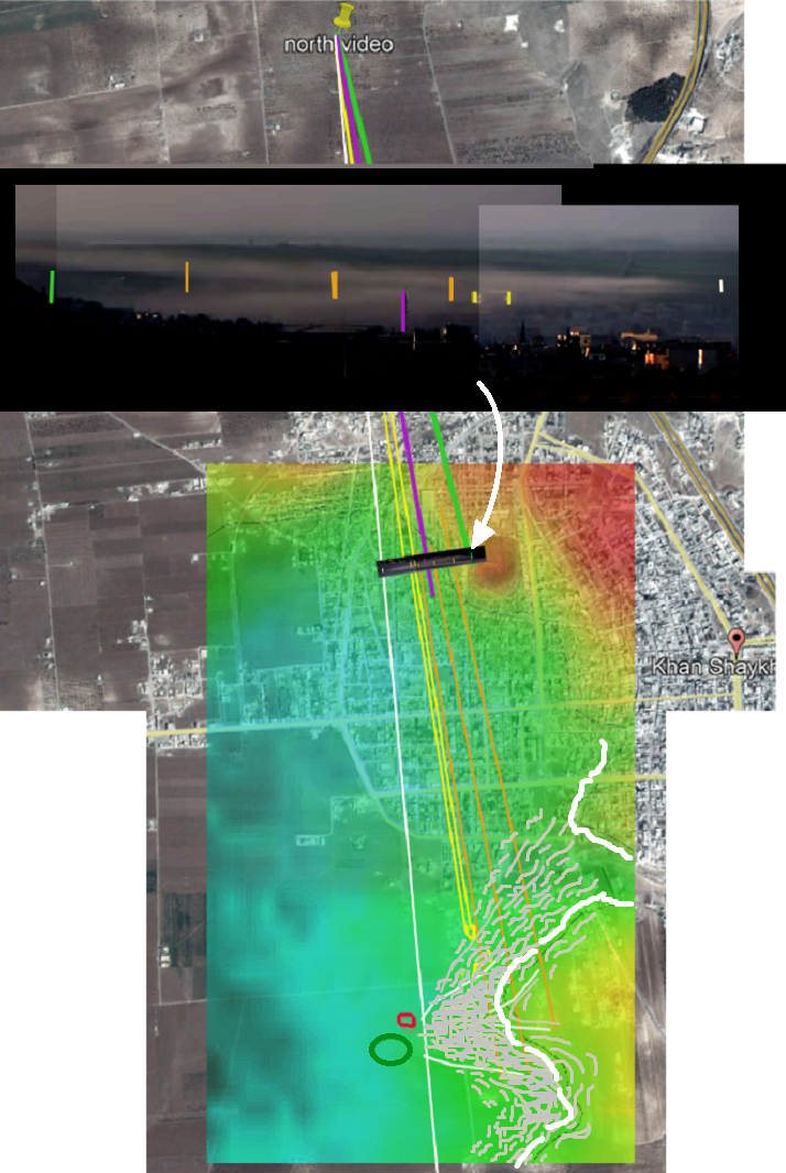
Exhibit H: more speculative, but more relevant (closer to where people died) - an apparently separate field of fog spreading north and east of the tel or hill in city center. This fog expands far to the left, to the edge of the frame at least, and perhaps to or past the sarin crater area to the northeast. This fog may be centered just where a mysterious expanding white vapor cloud had been at attack time. Below: a layered composite showing where the white cloud was and where the fog was later. It also spreads a shorter distance to the right, where perhaps the densest patch can be seen not far from its possible origin, just to the right, in front of the tel - somewhere north of its east edge.

The Location of that white cloud isn't certain, but seems close to the white circle below, very near to the tel. Considering wind plus wind shadow, some possible outlines of the fog field are traced on, white lines to show different density zones (somewhat). If I were to de-do this image now, the shapes would spread less to the north. Or maybe not - I'm trying to be reasonable and show identified victim homes (alleged) do fall within the potential danger zone ... of this fog from a place no one mentions. Looks like maybe a shed behind a possible school, which militants often use as bases. Someone knows who ran that place. But maybe it's from somewhere else on that same line of sight.

The Ground Level Problem (added Sept. 8)
Important belated addition: while the above stands unchallenged as showing a wind to the northeast above the ground, the most important level is at the ground, where any toxic gas would spread. In my requests for more thoughts, the most valuable was shared by Charles Wood, who knows weather and reviewed the above, agreeing with my findings.
https://twitter.com/Mare_Indicum/status/1033726039854178305
"restating my previous remarks, in KS conditions the wind speed and direction significantly alter with altitude - in the span of hundreds of meters AGL, The overall wind speed is low, especially at ground level. The analysis must be based on ground level evidence."
This is ultimately true, and I'm left making a circumstantial case, but a good one. Three, actually 4 points, 2 combined:
1) Indirect clues: Most likely direction, even slant
The most likely direction at ground level is about the same as in the connected air above that. It's probably slower and more variable, and it can be quite different, but not usually. It pretty unlikely that right below rooftop level it suddenly veers in an opposite direction, which we would need to keep the opposition story logical (let alone true).
Furthermore, the smoke plumes slant to the left at the top and as close to ground as we can see, which is about rooftop level. As noted the left movement is more pronounced higher up, but present near the ground. Most likely, it's present even on the ground.
Add Dec. 1, 2018: an image of plume 2, with the clearest slant to measure shows at least 9 degrees average at the bottom.

2) The white cloud
Bellingcat's Timmi Allen tried to show a SW wind at ground level using the mysterious white cloud, which does expand to the right (his tweet with helpful stabilized video). The problem is, it also expands to the left, in a different manner. I propose we see 2 forces: the cloud is internally expanding in all directions, (including the smooth billowing seen on the right), and also being hit partially with the wind (causing the smear off to the left). The reason it can expand right against the wind is that it's mostly in the "wind shadow" of the tel, the large flat hill in city center. The cloud seems to originate just northeast of it, so it would be shielded like this if ... the wind here was to the northeast, as we can see it is, at least this high up.
Here, (tweet w/new graphic) I also note a vertical wind shadow; at the top of the hill, the wind rolls across and skims off any vapor that rises too high, pushing it down as the air average out, angling down to fill the shadow a ways out, sort of excavating the cloud on its left side.

It could also look like a wind from the left, pushing the whole cloud to the right, and the right side is contained maybe by some counter-wind so it doesn't smear, but stays intact and puffy (or??). But all other wind signs at this level (that of the lower half of the smoke plumes) point left, including the bits of this vapor smearing back to the left - against the wind? No, this is a wind to the left, more active on the left, mostly blocked on the right. This shows there is a wind, and it's blocked by the hill, so it's moving east.
But this is still mostly a ways above ground. Looking as far down as we can see, the vapor spreads to the left. The upper-level thick fog runs at least to the edge of the frame here, probably well past it. And the really dense cloud part at rooftop level expands about half that far. Down at ground level, the white probably expands considerably further, probably about to the edge of the frame. And the cloud is still expanding, just a couple minutes after the alleged air attack, adding to this unclear issue.
https://twitter.com/Mare_Indicum/status/1033726039854178305
"restating my previous remarks, in KS conditions the wind speed and direction significantly alter with altitude - in the span of hundreds of meters AGL, The overall wind speed is low, especially at ground level. The analysis must be based on ground level evidence."
This is ultimately true, and I'm left making a circumstantial case, but a good one. Three, actually 4 points, 2 combined:
1) Indirect clues: Most likely direction, even slant
The most likely direction at ground level is about the same as in the connected air above that. It's probably slower and more variable, and it can be quite different, but not usually. It pretty unlikely that right below rooftop level it suddenly veers in an opposite direction, which we would need to keep the opposition story logical (let alone true).
Furthermore, the smoke plumes slant to the left at the top and as close to ground as we can see, which is about rooftop level. As noted the left movement is more pronounced higher up, but present near the ground. Most likely, it's present even on the ground.
Add Dec. 1, 2018: an image of plume 2, with the clearest slant to measure shows at least 9 degrees average at the bottom.

2) The white cloud
Bellingcat's Timmi Allen tried to show a SW wind at ground level using the mysterious white cloud, which does expand to the right (his tweet with helpful stabilized video). The problem is, it also expands to the left, in a different manner. I propose we see 2 forces: the cloud is internally expanding in all directions, (including the smooth billowing seen on the right), and also being hit partially with the wind (causing the smear off to the left). The reason it can expand right against the wind is that it's mostly in the "wind shadow" of the tel, the large flat hill in city center. The cloud seems to originate just northeast of it, so it would be shielded like this if ... the wind here was to the northeast, as we can see it is, at least this high up.
Here, (tweet w/new graphic) I also note a vertical wind shadow; at the top of the hill, the wind rolls across and skims off any vapor that rises too high, pushing it down as the air average out, angling down to fill the shadow a ways out, sort of excavating the cloud on its left side.

It could also look like a wind from the left, pushing the whole cloud to the right, and the right side is contained maybe by some counter-wind so it doesn't smear, but stays intact and puffy (or??). But all other wind signs at this level (that of the lower half of the smoke plumes) point left, including the bits of this vapor smearing back to the left - against the wind? No, this is a wind to the left, more active on the left, mostly blocked on the right. This shows there is a wind, and it's blocked by the hill, so it's moving east.
3) fog spread
If toxic fog spreading on the ground is the issue, let's look at the fog we can see spreading along the ground, around 15-30 minutes after the alleged attack. It should behave the same. I already explained why I think the SW fog area spreads east, if not northeast (hard to be sure). There's no topographical reason a natural, motionless fog would form in this triangular shape in that area. All that can explain it well is a mysterious single point of fog origin, a wind to the east, and then the topography putting limits on its spread to the east, channeling it more to the north and/or south. (see images above)
As for the northern field of fog, I think it started as that white cloud in the tel's wind shadow - a single point of origin, as suggested to the south - and it spread on the wind mainly to the north and east, with more expansion in all directions than you'd expect because the wind was blocked by the tel. It's impossible to define the overall shape of that field, how far it extends in what directions, except it's just a bit to the right of the white cloud, and a lot off to the left. (see graphics above, and note the one image of spread on the map has fudged outlines trying to include those red dots - it probably would not spread so far north, without first spreading a ways east as well.)
4) The Unseen Left Drift (add Dec. 1, 2018)
If the ground-level drift blocked from videw here were non-existent, allowing for downhill movement, the plumes would rise straight up in that span, so the visible parts would be directly above the impact points. But this new line-up shows plumes 1 and 2 both appear a bit to the left of their origins. Hence, even lower than what's visible, the smoke is already drifting left.

Pester RecordIf toxic fog spreading on the ground is the issue, let's look at the fog we can see spreading along the ground, around 15-30 minutes after the alleged attack. It should behave the same. I already explained why I think the SW fog area spreads east, if not northeast (hard to be sure). There's no topographical reason a natural, motionless fog would form in this triangular shape in that area. All that can explain it well is a mysterious single point of fog origin, a wind to the east, and then the topography putting limits on its spread to the east, channeling it more to the north and/or south. (see images above)
As for the northern field of fog, I think it started as that white cloud in the tel's wind shadow - a single point of origin, as suggested to the south - and it spread on the wind mainly to the north and east, with more expansion in all directions than you'd expect because the wind was blocked by the tel. It's impossible to define the overall shape of that field, how far it extends in what directions, except it's just a bit to the right of the white cloud, and a lot off to the left. (see graphics above, and note the one image of spread on the map has fudged outlines trying to include those red dots - it probably would not spread so far north, without first spreading a ways east as well.)
4) The Unseen Left Drift (add Dec. 1, 2018)
If the ground-level drift blocked from videw here were non-existent, allowing for downhill movement, the plumes would rise straight up in that span, so the visible parts would be directly above the impact points. But this new line-up shows plumes 1 and 2 both appear a bit to the left of their origins. Hence, even lower than what's visible, the smoke is already drifting left.

Scott Lucas of EA Worldview has been alerted to these findings, declines to take them seriously. Or so it seems...
Me, Feb. 19, 2018: 1/2 Scott, I need to put you on the spot here. I suppose you'll be tempted to do nothing and back away when and if you get what I've done. If so, I will cite the crickets as support (not the clearest, but if that's all I get...)
https://twitter.com/CL4Syr/status/965561827613597701
2/2 I think that's fair, as it's explained pretty well in the explainer, I'm handy for shortcuts as needed, you have a network to consult with. A few videos, known FoVs, 2 axes each, some correlation, that's it. Should be doable, IF IT IS.
https://twitter.com/CL4Syr/status/965562409875156992
https://twitter.com/CL4Syr/status/965562409875156992
Me, Feb 24: Hi, Scott. I suspect you decided not to debunk my wind findings
or any of the others?
 Is that right, or do you just need more time?
or any of the others?

https://twitter.com/CL4Syr/status/967574422193229824
He: Other priorities, especially re #Syria. I'll explain in due course why your diligent effort is based on a flawed assumption and why it is tangential --- if relevant at all --- to confirmation of #Assad sarin attack.
https://twitter.com/ScottLucas_EA/status/967653349645602816
Me: due course being maybe never ... close enough, thanks.
Me a bit later: Just an update - I will wait up. Sounds like you really have something I'm curious to see. Hoping due course isn't terribly long, but diligent stuff might require that. And apologies for it being muddled/scattered - limited time to manage it all.
Months later, just the other day here in August, I had a chance to ask again, and he replied:
"...your entire Khan Sheikhoun conspiracy theory is based on an amateurish and erroneous observation about a video of clouds on the day. Taking you through a Socratic examination of it wound up not being high on my priority list."
And
"...you didn’t establish anything on wind speed at time of Assad regime’s sarin attack on Khan Sheikhoun. You carried out a speculation based on fundamental mistakes based on your erroneous observation of a video of a cloud."
https://timhayward.wordpress.com/2018/08/20/alleged-chlorine-attacks-in-syria-2014-18/comment-page-1/
Adding here, I ask Mr. Lucas, or anyone:
What's erroneous here? Am I too amateur to tell left from right? Can no one be bothered to show how you do it right? How much handholding, babysitting, walk-taking or Greek-speaking would it really take to explain this? I bet by "tangential" and "flawed presumption" he meant something stupid like "Assad must have done it somehow, and it doesn't matter how, so the wind doesn't matter."
8/25: Mr. Lucas surprised me; he thinks the video is falsely presented and has no relevance. Or so he claims. Obviously, I'm looking for other people now.

Eliot Higgins was asked. August 24, and Bellingcat in general, and as usual, had NOT A DAMN THING TO SAY. And he's smarter than most at picking battles he can win and skipping ones he knows he cannot win. He skips every battle I offer him, because he knows I'm at least as smart at picking them.
I asked Art Wendley, an exceptionally engaging member of the Bellingcat camp - August 26: @ArtWendeley of course ... you always have something to say. What can you say about this? Any better than Scott did? And if all that left or right stuff is too technical for you, who else can u suggest?
He: Yes, it’s one of the strikes during the attack time frame but doesn’t show the Sarin strike itself.
He: Wind near ground very slow but moving differently to upper winds. Consistent with Sarin movement.
Me: now that I haven't seen. Evidence, aside from Timi's thing I saw? It wasn't right. Can explain if needed. Didn't see anything correct to support that.
He pointed to Allen's analysis, which I re-explained as above, and even Arty ran out of things to say. No one can show one thing blowing right, except - in poor readings - one half of the poorly-understood white cloud. The other half of the same cloud and everything else, including fog, moves left, not right, whatever else remains unclear.
Lucas also said that "With the Assad regime now controlling the area [in Douma], the OPCW is unlikely to get access.".. he is completely wrong and an ironic claim if you think about where the OPCW is able to visit safely. Take from that what you will.
ReplyDeleteYou may want to update the victim locations?
Basement is now where Abdelhamid wife, twins and Saleh children died. The same tall building next to the basement entrance is supposedly Yasser al-Yousef's house and where Shaimaa Ibrahim al-Jawha died on the balcony at the time of the dust plume videos (Yousra al-Yousef says they went out immediately after the explosion and Shaimaa died on the spot).
2 minutes after the explosions, Anas al-Khaled and Fatima al-Soussi fall down in a house close enough to have the front door blown open by the blast (likely Omar house as someone goes past on a motorbike but could be other impact point). In the next 15 minutes, dead animals and a man end up lying on the road to the west so perhaps you can plot the movement of the chemical cloud from that.
White Helmets family- I can't find the original info but must be Mazen al-Sayed as the same place is marked as Fouyad al-Sayed's home (father of Warda) house. Not very clear when she was affected, from the story they were all still in bed after rescuing many other people first.
Mohammed al-Yousef says his family fall to the ground "20 seconds" after the explosion but not sure of the exact location (so all affected before the fog).
You may not want to go through all that but can find all the videos and links if you do.
Looking back at the reports, an interesting thing re. persistence: although Dr Hazem Najam's sample collection that appears in the 'flip flop sarin collection meme' was actually on the 5th, he does say Turkey tested the samples and confirmed he was actually standing in "Sarin gas, with cyanide and intensive chlorine".
Of those AH and the basement is the that is 100%
Deletehttps://www.youtube.com/watch?v=76H1IYRaYN8
Not really seeing how the Yasser house fits with story of Ammar and the yard also other videos seem to be pointing to the same family but what looks like a different house. Other details all seem to fit the one by the basement.
Man, you are a nerd in a good way. Impressive that all that can be learned, and also that people had previously given different locations. But all in the same area, I guess? What on earth but a backwards wind reading made them love that area so much?
DeleteI might want to review and update, but not important at the moment.
Abdelhamid is a WH himself? Didn't know that. Some rescuer. Some home too. The basement looked like where people were squatting with some bedding. No sign of a real home, pictures of wife, burned or not...
that's not the home but where he left them, okay... someone else had already set up beds there? That's also strange.
DeleteGuilty- I just wanted to understand the witness story and possible timing for a sarin bomb. Locations would have been enlightening.
DeleteFor AH story, there is the possibility that they started at homes marked and went to the basement after the explosions. But with AH who knows? And no exaggeration that everybody seems to be in the White Helmets.
Also, despite a lack of vehicles (interesting to count how many say they have a car..), each rescuer only seems to drive a single set of victims to hospital.. perhaps someone went back for more victims in the untranslated testimony.
All not much help to you, important part is the houses to the south west are misleading when looking at the affected area.
To be more exact about what he said, Abboud al-Bakri goes to Fouyad's house "at some point" when he "can no longer get through" after rescuing people near the bakery.
DeleteHe says he "entered the house and found Foyaud's sister lying down with his daughters [Warda]. They looked as though they were sleeping".
So they may or may not have been in bed but certainly still inside the house, the podcast is not much help for exactly when this happened unfortunately.
Unsure whether this was meant to be Abboud al-Bakri in their artwork
https://www.instagram.com/p/BccBdW9gVEB/?taken-by=alyompodcast
seems to have blended his beard with the man in the original photo so possibly doesn't appear in any actual video or photo (I haven't spotted him yet)
https://metrouk2.files.wordpress.com/2017/04/pri_35542563.jpg
Bringing here for Scott's benefit: he responded again at Tim Hayward's blog.
ReplyDelete"Caustic,
You started with multiple assumptions from a fundamental error — you looked at a cloud which was not from the sarin attack but from one of many conventional attacks taking place on April 4, 2017 in Khan Sheikhoun.
Because the rest of your speculation is based on that error, it has no validity."
Helpfully, I suggested he re-think that, and show up here to fail in person. But maybe that's his idiotic last word. Not that he's an idiot, just saying idiotic things because it's his job.
And the other weaklings who won't say anything... they should be fired.
From my (trying to be) objective but cynical point of view, it is disappointing that the general 'anti-Assad' type response is to just call everything they disagree with "disinformation" with zero interesting analysis, sometimes even just making things up instead.
DeleteI don't know if you could view this (Channel 4 video)
Deletehttps://drive.google.com/file/d/1pnXbdHT-JzaE0l1wc16jCbeBtUJDO9h7/view?usp=sharing
They always seem to miss out the other student Ayham was detained with, that his mother was told he was dead long before the note and that there are no major injuries on his body (according to HRW). I wonder why they redact the section that says how the body ended up at the hospital on the document and why they would randomly send a memo asking how to dispose of the body when they have already supposedly have a system in place that thousands have gone through.
I have a post or maybe 2 in the works. The document referring to 227-2668? Indeed, Wiley and co. black out all the context. And both "M" and that note are suspect.
DeleteIs this sentence correct?
ReplyDelete"The direction could be SE or N. But it cannot be west, north, south, NW, or SW."
Did you mean to say "..could be SE or E."?
no, thax. You do lissnup. An E went AWOL.
ReplyDeleteRelating to your search for an intelligent rebuttal: apart from their problem, Rami doesn't recognise the KS JIM report calling it an obscure report distorting the original FFM report. Suggests he won't be able to add much here, seems a vacuous empty vessel like Lucas.
ReplyDeleteAlso KS, the latest thing seems to be to try and suggest that (S/1510/2017 3.46) "the team was unable to: (d) implement a complete chain of custody, by the team, for samples from source." is somehow ambiguous.
DeleteInterestingly, Mike King's request for the document relating to chain of custody shows it is not a public document https://twitter.com/MikeKingWriter/status/1042744165677850625
I never wanted Rami's input, just showing the challenge to show how even greater minds (…) can't remotely tackle my info, so he's, like... failing naturally, but probably not a "foreigner." What a content-free buffoon.
DeleteSo they acknowledge now chain of custody … can't be "implemented"? It was always clear they relied on trust, admitted or not.
King makes a good point, responded there, thanks.
If you think relevant, the KS school building marked as a false flag location is in one of the ALYOM videos. Not sure if there are any clues to whether still a school or white cloud
Deletehttps://youtu.be/4wZ6fSrSWLA?t=41
I am only assuming school but it did once had a sports pitch/field outside
Deletehttps://imgur.com/lQhjGlO
FWIW Yusuf al-Yousef's school on the ALYOM instagram is a different building
Deletehttps://imgur.com/GmNsFGe
I have a photo over here with a better view of the area:
Deletehttps://twitter.com/CL4Syr/status/1044903709644214273
No obvious clues, but worth seeing. Some fog machine could be set anywhere in these buildings or walls, depending. water supply might be important (deduced from SW fog area being next to a water reservoir)
I never saw an ALYOM video, didn't know what that was. Smiley little Yusuf's not going to school there is consistent with (weasel word) this likely school now serving another purpose. Or he's in that other school district... lol. Or it's a girl's school - if these exist (I suppose they have to learn SOMETHING?). All totally unclear, but this always looked to me like the spot.
https://twitter.com/Qoppa999/status/1044905101566054401
DeleteSchool clearly taken over by someone who also got attacked by others on the ground, firing projectiles into it prior to Jan. 2015. Maybe army at one point, not teacher's union. Since, prob. 2 clashing oppo. groups, maybe 3. In 2017, even in these photos? may be abandoned. Looks empty.