Then an outside view - different bands of fragmentation damage describing a pretty consistent arc that angles up to the right and then levels out past the 3rd window - this makes for an impact from the left or north of west (or northwest) - about the northernmost angle shown in my range. (even better view here: https://t.me/donbassr/11856)
Not geolocated - impact damage unseen past a downed power line, some fires as if from spilled fuel
Trudokskaya mine was cited as the area by mayor Kulemzin, who said 6 transformers were knocked offline sop that "Residents of 814 houses of the private sector, an outpatient clinic on the street were left without electricity. " - https://t.me/kulemzin_donetsk/3319
In all this, there were luckily no reported deaths, nor even injuries (that I noticed). But that luck didn't hold everywhere.
Petrovsky district, Trudovskaya: 2 impacts at a bus stop - a man was killed - his body from the waist down is shown. The rest is scattered, some parts hanging from trees.
Lancaster gestures south when explaining where the shells came from - over a wall on the street's south side, first impact at that curb - next a dirt crater across the street and a bit west. Distant homes match with some to the north. A bus passes: route 60a, perhaps. Maps say the route here is 60Б. Ignore E & F crater labels; this is all attack spot D now.
Above: both impact craters, tail section of one of the mortar shells used. Right: a map I made to check on the southern frontline, as south origin was alleged. Due south, 6.4 km from the impacts and further out is Ukrainian-held. To the SW it's a bit closer, and to the SE a bit further out.
Analysis: Soil displacement: unclear, with most of it hidden under the grass. Some torn ground right of center might be the "splash" pattern indicating arrival a bit from the right or east. The major part of the victim's body was flung a few meters to the NNW. Frags dense enough to tear apart a body, directed mainly from the waist up, on anyone close to the road means those were the high/forward fragments. Curb hit: section blown out to north or NNE, concrete rubble spreads north, maybe a bit more to the NE, but likely being side-spray. Overall: visual say a bit from the SE, but that's not conclusive. Broadly from the south - SW to SE - is the right call.
46 Donskoy St. - crater just NE of the house, damaging this wall, almost entirely top to bottom as far as we can see (below the sloping red line might be unmarked) - "splash" pattern appears only at the sides - read as northwest origin and from the details, I agree.
Same report, violations table: I don't think it shows anything that isn't mapped. A lot of impacts just around the line of contact, and a lot of shells (70?) seen fired to, and explosions at, a spot 3-5 km NE of Avdivka, traveling NW-SE. That can't connect to any of the spots I had been looking at, but maybe to ones just off-frame to the north. I might have seen some of these outlying impacts but skipped them just for their location. But most of them have gone unseen, and likely include military targets.
This same day, Ukrainian shelling hit its highest level, over 1,400 explosions recorded across the Donbass (on both sides). The Donetsk Filtration Station was shut down by 2 of these shelling attacks, crippling water supply to much of the DPR, just as Ukraine apparently shut their spigot to the LPR, among other escalations of their assault on civilians in the breakaway republics. The day saw its first death in Donetsk city, but people had already been killed by shelling of the outlying villages and Horlivka, and in and around Lugansk, and it only seemed to be getting worse everywhere.
DPR Online would say this day, citing Defense Minister Eduard Basurin "The situation at the front in Donbass is simply critical. ... A civilian was killed,
3 schools were damaged, hospital No. 14 in Donetsk, 2 residential buildings, a power line, a 35 kV substation were damaged, the Donetsk filtering station was de-energized, the water supply of the republic was limited." Basurin was quoted as saying “In order to protect the civilian population, our defenders are forced to return fire from weapons not prohibited by the Minsk agreements, suppressing enemy firing points.”
Hospital: unverified. The 3rd school was somewhere else (no. 47 in Horlovka?) and as for the filtration station, see
part 1, last section.
Kyiv's people predicted Russian false flag attacks, but of course the real evidence points to Kyiv's own forces. Is that why they were so confident in predicting Wagner false flags?
22 February: Grad rockets on Kyivsky District
15:10 - n.p. Vodiane - Donetsk (Kyiv region): 5 rockets were fired from the BM-21 "Grad", and 12 shells of 122 mm caliber.
"For the first time since May 2018, when shelling the Donetsk People's Republic, the enemy used rocket artillery ... Ukrainian militants from the positions of the 56th motorized infantry brigade opened fire from a multiple launch rocket system BM-21 "Grad" in the Kievsky district of Donetsk, firing FIVE missiles."
"From the positions of the Armed Forces of Ukraine located in N. p. Vodyanoe in the Kievsky district of Donetsk, the enemy fired 5 rockets from BM-21 installations and 12 shells of 122-mm caliber. As a result of the shelling, the administrative building was damaged."
2 damage spots are shown: mainly a red brick place with trees, and also an apartment building where a woman speaks. The latter is too general to locate, and the former doesn't look like the main city admin. building at 48.0159713,37.7995546, which is not quite in the Kyivsky district. Another that is: 36 Kyivskyi ave. - 48.0475702,37.7774067 - damaged by shelling on 6 March - also not a clear fit - not bare red brick. No location, no directions set, no analysis.
Despite the escalation to Grads rockets and maybe to more central locations, there don't seem to be many attacks on the city this day. It was quality over quantity.
23 February report, covering the 22nd, is the last regular SMM report with mapped violations.
Violations table: from a SMM position "about 3km WSW of Donetsk central railway station (non-government-controlled), 6km NW of Donetsk (city center)" was heard:
8-10km S 1 Explosion, Undetermined nature, 22-Feb, 10:55
8-10km S, 2 Explosions, Undetermined nature, 22-Feb, 10:59-11:00
Then looking separate but connected:
4-6km NW Heard 6 Explosion Undetermined, Artillery (type N/K) 21-Feb, 18:31-18:47
maps out so ...
Any grad shelling in the Kyisky district - around 3pm or any time - went unnoticed. An explosion around Pisky isn't explained in the table, that I found. The rest were observed from the given spot - 3 explosions in Petrovsky around 47.9520778,37.7029001 (residential) - six around Spartak and the airport - not AT the shown spot or any one spot, just estimated around there.
DPR-linked reports of attacks in these areas:
Pisky explosion as mapped: not mentioned? Likely outgoing DPR fire. It was mostly Ukrainian-held.
Petrovsky: 18:40 - n.p. Maryinka - Donetsk (Trudovskaya village): 16 mines were fired with a caliber of 120mm;
https://t.me/dnronline/57985
Trudovskaya is a big portion of the Petrovsky district, so possibly the same spot the SMM estimated then mapped, but the times don't match - 10:50-11 am vs. 6:40 pm. Somehow there's no overlap in reportage here.
Shelling of Spartak, the Airport, and "Volvo Center" ruins near Pisky (likely position for DPR fighters) don't seem to come up at the SMM's times - 6 blasts near the airport at 6:30-6:47 pm. That's when the JCCC reports 16 blasts in Petrovsky instead (6:40). Intead, they report it heating up later that night or early on the 23rd.
23 early https://t.me/militarydonetsk/2337
Before dawn, the formation of Zelensky from positions located in the settlements Avdiivka and Vodyanoye, fanned out (fired on) the territory of the Donetsk airport, the Volvo center and the settlement Spartak with mortar fire. Released about 15 82-mm mines.
https://t.me/DNR_SCKK/6081
On the night of February 22 to 23, the Ukrainian Armed Forces opened fire from 82-mm mortars on the village of Spartak. The fire of Ukrainian militants damaged the summer kitchen, which started a fire.
23-24 February
CNN, 23 February: "Russian state news reported on Thursday that Ukrainian security forces have shelled the pro-Moscow region of Donetsk ... Russian state television also reported ... CNN could not immediately verify" - probably referring to the previous day's escalation of shelling central Donetsk with GRAD rockets ...and for good measure, CNN reminded readers that "The US State Department has warned that Russia may use so-called false flags, including claims that Ukraine is attacking Donetsk, to justify an invasion."
No escalation of shelling in Donetsk city the 23rd - the worst seemed to be in Lugansk and worse yet at nearby Alchev'sk. Jacques Baud: "The Ukrainian artillery bombardment of the Donbass population continued, and, on 23 February, the two Republics asked for military assistance from Russia. On 24 February, Vladimir Putin invoked Article 51 of the United Nations Charter, which provides for mutual military assistance in the framework of a defensive alliance."
On that given basis, tanks rolled into Ukraine on multiple fronts the following day. And that was "unprovoked," as they say. but once Russia had invaded, Ukraine's own next-phase contingency plans would go into effect, and these plans apparently included steady, mid-scale shelling of urban centers, residences, schools, hospitals, etc. across the Peoples' Republics. From the 24th forward, I'll skip external news reports and commentary, and stick to shelling incidents as reported (with some included commentary), and especially as shown.
24 February: Putilovka microdistrict Clobbered
24A) Zasyadko Ave.
Donbass Reshaet (Donbass Decides), in Telegram:
"During today's shelling of the Putilovka microdistrict in the north of Donetsk, four people were injured - two women and two men. There are large blood stains near the store on Zasyadko Avenue. The facade of the store itself is badly damaged, almost all the windows in the house where it is located have been blown out." Night time video included.
https://t.me/donbassr/12889the Putilovka microdistrict is in Kyivsky district - more central than the located shelling so far. Geolocated to 8 Zasyadko Ave. - 48.0549697,37.7795966 - Yandex 2010 street view: upper right in the plate below.
.png)
copious blood across the shop stairs (not shown here) - frag marks seen across the stairs, lower wall - more intense shrapnel damage visible at bottom of the stairs, right edge, debris from the stairs piled up the same right edge of the stairs, and a planter just around the corner is smashed apart. The blood on the stairs from people who didn't die probably means lower body injuries, from other low-flying fragments, like those into the stairs and planter. Low fragments, including into the pavement, lower walls and legs happen behind an angled shell detonation. This happening on the north side of the street suggests behind is partly north. The way some debris is piled up the stairs along the edge means the impact was a bit west of that edge, but it doesn't set the overall trajectory. Still, a bit from the northeast seems possible.
Several impacts shown at given addresses on Zasyadko Street, (incl. 10a, City Specialized Children's Home), Aristova Street, Kievsky Ave - some readings are shown - not northwest but rather due north at Zasyadko 6 (2 impacts, one by a tree and one at the edge of the roof) AND some from WNW - (maybe just one impact at Zasyadko 8 a bit west of where I estimated, with a pothole coincidentally about where I had the impact - or 2 shells hit, both in the street. review pending.)
24B) Children's Hospital
"Being unable to stop the advance of the People's Militia forces, Ukrainian punishers take out their anger on the civilian population - the city children's clinical hospital suffered from their fire."
https://t.me/nm_dnr/6374
"A correspondent of the Donbass decides channel captured how Donetsk City Children's Clinical Hospital No. 1 and two adjacent houses look like after yesterday's shelling. This is only a small part of the buildings damaged by the Armed Forces of Ukraine over the past two days in the Putilovka microdistrict."
https://t.me/donbassr/13115
Location: city children's hospital in the Kievsky district, 61 Kyiv Prospekt, 48.0549526,37.777608
2 points of damage shown at the hospital, both to the west-facing main wall, plus at least two others I can't place yet. 1) a direct impact on the upper north corner with oblique frag marks beneath it, of walls facing north and west = from the north & west. 2) a ground impact somewhere along the facade has a band of frag marks that angles up to the right = from the north & west. The band seems to curve as if it were angled somewhat into the wall, not alongside it. That's from the north and the west.
Crater near north end = another shell. I don't see it connecting with the frag marks so far ahead, but perhaps - 2 or 3 shells total.
Frag pattern start vs. full, for comparison below. The same hospital would suffer a second attack, again it seems with 2 shells, a week later (see below, March 6).
At least EIGHT residential buildings and 2 centers for children were damaged with quite a few shells. This was no accident. There are some provided visuals, not placed. But anyone bored might try with the help of these given addresses:
https://t.me/nm_dnr/6380 As a result of massive shelling by the VFU in the Kievsky district of Donetsk, houses were damaged at Kyivsky ave 61 (children's hospital), 63 (just north at 48.0561814,37.7781431); st. Aristova 1, 2, 3, and off the street, 7 (next entry) and st. Zasyadko 4, 5, 6, 8 (as covered above). Oh, and they missed Zasyadko 10 or 10a with the specialized children's home. All but the last mapped at right. I might come back correlate some scenes, assess some damage. One more for now...
24C) Donetsk College of Restaurant Service and Trade
A few years ago, a Ukrainian shell flew into the Donetsk College of Restaurant Service and Trade, which is located in the north of the city. Yesterday, a new shell of the Armed Forces of Ukraine repeated the same trajectory and hit the same place.
https://t.me/nm_dnr/6380 - photo of this alongside other damage, posted the 24th, suggesting it happened then, as do the above sources.
Location: Aristova 7, but not really on that street - about 80m north of the hospital, 24B.
front entrance faces south, looks fine. Damage is probably to the north-facing back side, with some indication it came from the right - there's a radial "spalsh" pattern centered on the impact point - for that to happen, the acute-angled side has to be to the right, or the shell arrived from the right = west. West + north would again = northwest.
more: https://t.me/nm_dnr/6397
https://t.me/nm_dnr/6396
On February 24, armed formations of Ukraine shelled the Kyiv district of the city of Donetsk. Being unable to stop the advance of the People's Militia forces, Ukrainian punishers take out their anger on the civilian population - the City Children's Clinical Hospital and the Lyceum of Restaurant Service and Trade, as well as the houses of local residents, suffered from their fire.
24 Feb., other
24D) Letnaya street, Petrovsky district
"Consequences of the shelling of the Petrovsky district of Donetsk. The correspondent of the Donbass decides channel managed to film the destruction at 2, Letnaya Street. Apparently, it was a 120-mm mine."
https://t.me/donbassr/12824
That address is inside the district's circular center area, at 47.9454074,37.6210515
Video is low resolution, hard to say what was hit where. Better images form the same incident might help. If anyone runs across that, let me know.
https://t.me/nm_dnr/6357
https://t.me/nm_dnr/6392
ok - back/west side, impact quite near, blew out half the area marked green - frag pattern angling up to the right = from the left, which is north, plus probably some east or west angle.
https://t.me/donbassr/12844
This is today's arrival along Aristova Street in the Kievsky district of Donetsk. “It is quite possible, a mine,” said a subscriber of the Donbass decides channel, who sent us a photo.
The facade of the building was cut, glass was broken
Aristova 18? 48.0590447,37.7798402 - in Putilovka microdistrict
What seems to be an unrelated pothole dominates the view, but there seem to be dense frag marks on the distant, probably west-facing wall, from another and closer impact. If so, that shell was probably from the west (proximity to wall) and north (marks angle up to the right)
25 February
Kuibyshevsky district
25A) January 9th Street, house
https://t.me/militarydonetsk/2782
Arrival almost in the center of Donetsk near the stadium "Shakhtar" That didn't help locate this spot at all, suggesting Shaktar hotel and plaza near Donbass stadium. That's not where it is.
https://t.me/chp_donetskv/9406
The results of today's shelling at 11.45 on January 9th Street (Margo Furniture Center).
Correct placement - big help. - 47.9974577,37.776183 - video compared to 2011 street view:
This street runs NNW-SSE - view faces SSE - The band of fragment marks on the building at left angles up to the right (or forward, or SSE), suggesting a trajectory down the street, so fired from the NNW or similar (northwest, or north). Mapped with next entry.
25B) January 9th Street, Auto repair shop
https://t.me/kulemzin_donetsk/3397
Civilians were wounded as a result of shelling from Grad multiple launch rocket systems in the center of the Kuibyshev region.
Damage at Margo furniture (probably from this impact) + other impacts - one maybe just west in the garages there - impact from the NW as well (debris to the right and towards the camera, low, oblique marks on car) - perhaps the building north of that as well - some 3rd strike in presumably the same area.
See also: https://t.me/donbassr/12999 - https://t.me/donbassr/13004
Homes along Kyivsky Prospect 25C) Kyivsky 63 again
"A resident of the Kievsky district of Donetsk was wounded by the fire of the Armed Forces of Ukraine A man was wounded as a result of the shelling in the Kievsky district of Donetsk at the address Kyiv prospect, 63 apt. 39. In serious condition, the victim was hospitalized at the Republican Trauma Center."
In the nighttime video report that text goes with, a damaged balcony is specifically shown - not clear here, but blast and frag marks angle up to the left = origin from the right. Then an inset map shows fire was from the southwest. So this must be a west-facing wall, the shell impacting from the west and the left/south.
I can't understand what the guy says, but ... I'm 98% sure this is on the building's north side. In a daytime view (below), the damage band is clearer. A hit from the left and into this wall WOULD be SW, but IS northwest. What the SW reading was based on is unclear. This video, thinking it was on the west side?
See the right side there: we're looking west across Kyivsky Ave. There's an elevated concrete whatever, kind of like an aqueduct (?). See next a later view SW down Kyiskyi from a bit north of here. It's that thing on the right. GM street view down the north face also matches for the 2 little shacks, other details. The west side does not match. At least it seemed that way on a quick review. Will double-check. Maybe.
Note 63 Kyivsky has been hit already the day before. when the next-door children's hospital was attacked.
25D) Tarkhanova 5a
https://t.me/nm_dnr/6417
"Ukrainian militants continue to terrorize civilians in the Republic. Today, as a result of the shelling of residential buildings at the addresses: Kyiv Prospekt, 54 and 52, as well as Tarkhanova 5a,
a woman born in 1968 died. In addition, three local residents were injured." That's just the second fatality I'm aware of inside city limits.
Address location: 48.0599677,37.7738998
5a unlabeled, probably on the back side of 5 - just a tiny shack with an outhouse half its size? As it's a sort of micro-house that's "out," I'll call it that either way. Fence badly punctured by fragments in a band sloping up to the left = from the right, roughly up the street NW.
Yellow outlines show where some concrete was knocked out of the fence, and some of it smacked into the outhouse. It's not hard to see this had to be on a line that slopes up, to the left, and towards the outhouse. That it happens so high up to the left of impact is what helps show the shell came from the right, up the street, or from the northwest. The fragments that punched through and punctured that poor woman to death - they all went on paths that testify to this truth about who killed her with their terrorist shelling. They're off somewhere to the northwest.
Note: right down this street also points right to the damaged balcony at 63 Kyivsky, hit this same day, non-fatally injuring another resident.
26 February
26A) Kindergarten No. 251
Ukrainian criminals continue their punitive operation against the children of Donbass. Kindergarten No. 251 in the Kievsky district of Donetsk (Buslaeva st., 35a).
video https://t.me/donbassr/13231
48.061179,37.7783032 crater at NW corner - marks on west north and sides angle up from that corner - clear northwest origin. To the sides are curb damage (orange) and side-spraying debris (gold) that form a line - that should be perpendicular to the trajectory. That gives an unusually clear reading of roughly 118 degrees, 298 NW reverse azimuth. That line runs from here back over the airport, to north of Vodiane, south of Umanske and right to the distant Orlivka, depending on range.

26B) 5 Myronova St.
The consequences of the massive shelling of the Kievsky district of Donetsk tonight." Massive corner damage - shown at right with no location clues past the district.
seen later: 2/28 https://t.me/kulemzin_donetsk/3453
"In the Kiev region on the street. Mironov, the forces of the employees of the KKP "Donetskgorsvet" restore lighting after a massive shelling."
There's a 2011 street view where we can see this is 5 Myronova St - 48.0444601,37.7772538 - about a kilometer south of the kindergarten 251. Northwest corner impacted = probably from the northwest, but perhaps the west or north.
https://t.me/nm_dnr/6480
This time, the Kyiv district of Donetsk was subjected to shelling. As a result of the shelling on February 26, civilian infrastructure was seriously damaged: a bus stop, houses of civilians, a boiler house, a heating main. As a result of damage to the Mayak substation, more than 5,500 people were left without electricity.
26C) Listoprokatchikov st.
https://t.me/militarydonetsk/3176
Consequences of the shelling of Donetsk by Ukrainian armed groups. st. Listoprokatchikov, 10
Difficult to establish what was hit where, but I'll include it on the map below.
renovated apartments - this address among those noted in August 2021 https://t.me/kulemzin_donetsk/1752
"In a residential building on the street. Listoprokatchikov, 10, which was repeatedly subjected to shelling, repairs are in full swing. New doors and windows were installed for the residents, they started facing the walls of entrances and apartments, replacing internal communications, and the next step is the external repair of the facade."
https://www.google.com/maps/place/Lystoprokatnykiv+St,+10,+Donetsk,+Donets'ka+oblast,+Ukraine,+83000/@48.0622652,37.7704727,3833m/data=!3m1!1e3!4m5!3m4!1s0x40e085391f4b34b5:0x76ed6a7e31f7c606!8m2!3d48.0622616!4d37.7879822
All 26 Feb. placed impacts on a map - the kindergarten 251 reading is the clearer one, not exactly this line drawn but very close. 5 Myronova St. is pretty open, including to a line convergent with the other. The nearest settlement where they might intersect is Vodyane. That's enough to call it the "likely" attack area.
Other
https://dnr-sckk.ru/fotoreportazh-posledstviya-obstrela-g-doneck-kievskij-rajon-2/
Kievsky Ave., 23/13, a 16-year-old resident was injured - a mine-explosive injury, a scalped wound to the occipital region.
🏠Damage/destruction:
▶️ 4 Garage Street, warehouses damaged;
▶️Politboytsov Street, 10, the boiler house, the heating main were damaged;
▶️Politboytsov Street, 10b, the boiler house of se Donbassteploenergo was damaged," glazing, power transmission tower;
▶️TP "Mayak" was damaged, 26 TP, 5500 subscribers without electricity were de-energized;
▶️Kievsky Avenue, 23, damaged trolleys for the movement of urban transport;
▶️Mironova Str., 5, apt. 15, significant damage to the living quarters of the apartment;
▶️Mironov Street, 5, apt. 12, the glazing was damaged;
▶️Mironova str., 7 kv.11 – glazing, gas pipe were damaged.
I didn't find any visuals for the 27th.
28 February
28A) Korpus 21K1
https://t.me/militarydonetsk/3793
Donetsk. Panfilov street. Wisniewski hospital area
https://t.me/nm_dnr/6540
https://t.me/militarydonetsk/3787
https://t.me/militarydonetsk/3781
https://t.me/chp_donetskv/9891
https://t.me/donbassr/13639
Location: 48.0208912,37.7820093 - southwestern Kyivsky, near city center - The westernmost tower #1 at "Korpus" residential complex, 21 Paniflova ave. - building labeled 21K1 on Yandex maps - trees and lot with small buildings is to the north. Cars burn on the north side, facade invisible - east face intact up to the corner. Later view of north face damage shows impact was partly from the north, at the northwest corner, and impacted from the right = west. Another northwest-origin impact.
distance view https://t.me/donbassr/13632
https://t.me/donbassr/13671
"Today, during the shelling (https://t.me/donbassr/13632) of the Kievsky district of Donetsk, among others, several houses on Lavreneva Street were damaged. House number 9 got the most" (shown). There was just light damage next door (north) at #11, tearing up the green awning we can see in satellite views. "The owner's car was also wrecked. And his neighbor Sergei's house was less damaged, but the Ukrainian shell destroyed three cars - his and his son-in-law, with whom they were in the house at the time of the shelling."
Loc: 48.0395265,37.7952317 - Google Maps street view matches video scene. Lavraneva street runs N-S, with #11 and 9 on the east side, facing west. Of course. Impact partly from the west, probably + north.
28C) Same place - double tap
https://t.me/donbassr/13671 (still) ... As Sergei told the Donbass channel, when the shelling stopped, all the neighbors went out into the street to find out if everyone was alive and well. The Ministry of Emergency Situations and gas workers arrived. And then, 30 minutes after the first shelling, the street was again covered with shells.
One of them landed about a hundred meters from the people who left, in the place where the gas workers were standing. (https://t.me/donbassr/13665) One of them, 31-year-old Alexander Shevchuk, died. Moreover, in front of his father, who was wounded, like another of their colleagues.
That seems to say the father was working together with his son, and had to watch his son die - one of the hardest things to go through, as I hear. That's fatality number 3 that I know of.
"AFU destroys the infrastructure of Donetsk and kills its inhabitants Today, during restoration work in the Kiev region, a Donbassgaz brigade came under fire (https://t.me/donbassr/13632). ◾️One locksmith died. Two were severely wounded. The owner of the house, near which the tragedy occurred, Galina Horkhula, says that at that time her mother was in it with her grandchildren 5 and 15 years old. Luckily, they were unharmed."
The impact in the street is at 48.038796,37.7950508 - a ways south from the damaged homes - view across from 2 Lavraneva st. & 23 Novomoskovskyi lane. Damage and direction not visually clear, but probably the same as the earlier strike. Mr. Shevchuk's covered body seems to be right at that corner just a few meters away.
28 February, Mine 29
Mine 29, Petrovsky district - home destroyed
https://t.me/donbassr/13664
As a result of the night shelling of the village of mine No. 29 in the Petrovsky district of Donetsk, a family of 5 people found themselves homeless. They say you can't stop time. The clock in the destroyed house shows the exact time of the shelling: 01:55. A family of five lived in the houses at 4/3 Yunatov Street, including a 13-year-old teenager.
Address at 47.9554004,37.6599284
big crater
https://t.me/donbassr/13637
Petrovsky mine 29 - worse than 2014, according to locals
https://t.me/donbassr/13670
28 February, Kirovsky
https://t.me/nm_dnr/6550
"Consequences of the shelling of the Kirovsky district of the city of Donetsk by the Armed Forces of Ukraine" Not placed.
1 March
3-1A) Skyline/Miners' Square
"The consequences of the shelling of Donetsk by the Armed Forces of Ukraine. A local resident died at the address of Young Miners 43. At the address of Young Miners 45, a gas pipe caught fire. At Shakhtyorskaya Square 2,
two local residents were killed and a car burned down." (
https://t.me/militarydonetsk/4188)
That's at least five civilian deaths so far, and probably several dozen seriously wounded, including with lost limbs.
"Ukrainian punishers continue to fire at the Kyiv region from multiple launch rocket systems. Two people died in the area of Shakhtyorskaya [miners'] Square." Head of Donetsk Alexei Kulemzin said. "Request to residents to move away from the windows! If possible, move to the shelter. Be sure to keep documents and communications with you! Take care of yourself and be vigilant!" - Kulemzin turned to the Donetsk people.
images:
https://dnr-sckk.ru/fotoreportazh-posledstviya-obstrela-voroshilovskogo-rajon-g-donecka/
https://t.me/militarydonetsk/4156
https://t.me/militarydonetsk/4157
https://t.me/militarydonetsk/4155
https://t.me/TK_Union/8418
https://t.me/chp_donetskv/12965
2 dead https://t.me/militarydonetsk/4167
https://t.me/nm_dnr/6570
https://t.me/nm_dnr/6575
Location: 48.0383349,37.7799044 - mid-north Kyivsky district, at the "Skyline" tower that is quite familiar from almost any view of the Donetsk skyline. Its broad sides face basically north and south, and with the usual NW fire, I expected this was the northwest corner. But the plaza with domes is on the south side. The impact was near the SE corner of the south face.
This close south of a very tall building = not from any northern angle, unless it was a steep-diving rocket or missile. And while that's unusual, the fragmentation pattern is pretty horizontal (so the impact was fairly vertical). The moderate slope of damage we do see points back to the left = from the west, maybe SW or NW if vertical enough. From SW might leave a band of marks that levels into an arc, which I don't see. Impact from the west is more consistent with the apparently straight band of marks all to the side.
West to WNW is the most likely basic origin of fire. Just how far depends on the exact weapon and stuff I don't know. Maybe 15 km? Nevelske is on a good line that far out. They might have aimed for the building's west face and overshot a bit - or they might have aimed for city's name plate, as it were, at the mentioned Miners' Square, and aimed a bit wrong.
https://t.me/dnronline/58932 "Video of the entire shelling of the Kyiv region and Shakhtyorskaya Square" from a distance shows at least 3 smoking shell impacts inside the city, none of them clearly at Skyline (visible in the right-hand distance, and with the impact on the opposite side). At least 18 blasts of comparable loudness are heard, possibly all landing inside the city. I think the view is from the northeast facing southwest, and the seen impacts are closer to the camera than Skyline, or north and east of it.
3-1B) Izyum
https://t.me/kulemzin_donetsk/3496
VFU shells hit the Izyum store in the Petrovsky district. There are people injured. The information is being specified.
47.941387,37.6002215 north face damaged top to bottom, low detail view - direction unclear except probably from the north + something. Same face of the same place hit again in May: https://t.me/izvestia/89568
1 March, Others
https://t.me/kulemzin_donetsk/3490
"The consequences of the shelling of the Kuibyshev district of the city." Not placed.
Now in March, shelling increases and so does documentation. But we have about enough for now, don't we? I'll start skipping most and just sharing a few I already looked at or could easily say something about.
2 March
3-2A) School No. 71
https://t.me/nm_dnr/6609
The Armed Forces of Ukraine are aiming fire at civilian infrastructure facilities. Yesterday School No. 71 named after P.F. Batula city of Donetsk.
48.0289518,37.7176455 - GM street view matches ok, but it's not exactly clear where the impact(s) are, or what the damage is.
3 March
https://t.me/militarydonetsk/4845
The consequences of the shelling of the Kyiv region, st. Deciduous 9
same, video https://t.me/militarydonetsk/4830
photos https://t.me/nm_dnr/6695
clearer video https://t.me/nm_dnr/6707
north edge of the city - 48.0379169,37.8051694 - alley runs north-south - view faces north, and affected homes seem to be on the right - reasonable match with 2011 street view - Seems like the shell impacted the big tree leaving it in pieces, blew out the fence, and marked surfaces all around - damage slopes up to the south - car, west-facing wall, brick entry structure, remaining west wall passed over, and a north-facing wall of the next home to the south was partly collapsed - so the shell came from some combination of north and west.
pics f/c, maybe - it's a messy, unclear scene, hard to explain, and not my best case. We have more than enough here already, right?
4 March: Hospitals
https://t.me/DNR_SCKK/6423
https://t.me/DNR_SCKK/6428
https://t.me/DNR_SCKK/6486
Addresses: Shumana street, 16,18; - Yakovleva street, 8 - Instytutska 11 - Savrasova 83, Savrasova 3 (middle, at 47.9743277,37.7049775), Semashka 3a
"Consequences of the shelling of a maternity hospital and a polyclinic in the Kirovsky district of Donetsk" Not much visible damage on the buildings. West or WSW origin shown for a dirt crater at Semashka 3a (not verified).
5 March
5A) school no. 116
https://t.me/online_dnr_sckk/10211
17:20 - N.P. Novomikhailovka - Donetsk (settlement, mine "Trudovskoy"): 4 mines with a caliber of 120 mm were fired.
https://t.me/DNR_SCKK/6530
According to updated information from the administration of the Petrovsky district, during repeated shelling from the VFU MOU "School No. 116 of Donetsk" on the street. Samarskaya, 1 - ceilings collapsed."
47.9472463,37.565835
"At the address Vyborgsky lane, 1, it was recorded damage to the low-pressure gas pipeline with subsequent burning." (just south of school's south corner)
photos https://t.me/DNR_SCKK/6550 - https://t.me/militarydonetsk/5536
To do later (not neccessarily by me): compare the damage seen on the different dates, sort out what happened when.
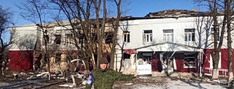
6 March - Children's Hospital, Kindergarten
6A) Children's Hospital hit again
https://t.me/militarydonetsk/5817
As a result of another shelling, the city children's hospital in the Kievsky district of Donetsk at the address: 61 Kyiv Prospekt was damaged. The strength of the gap can be judged by the spread of pieces of earth and trees. Shells fell on the streets near the houses, as well as in the hospital building, but no one was hurt.
at 48.0549526,37.777608
Images show damage from least one impact on the front side, another on the back side, among damage to other buildings shown - front side = west-facing wall, impact from the left = north. Back side: soil spreads widest to the south and east = from the northwest.
If you've been reading or just following the images, the upper left view should look familiar. About the same was seen back on 25 February. Is it the same band extended across two of these 3-window sections? Comparing the two bands of damage, yes - the frag marks are still there from a week earlier, and only the impact behind is new. Photos do show another impact across the street from the hospital's north end (right), and another even closer to its south end (below), so at least 3 shells were sent, none of them directly damaging the hospital.
6B) Kindergarten no. 392
During the shelling from the side of punishers from the ranks of the Armed Forces of Ukraine, as a result of a direct hit, a kindergarten in Donetsk was seriously damaged. 11, Aristova st.
Location: 48.0573667,37.7782765
One impact is quite readable - close to parallel with this west-facing wall, so mostly from the north. The wall has some angle and the impact has to be somewhat into the wall (peak of damage arc is ahead, and it's left of that white bar in the corner). So it's a bit from the west too = NNW. The view above is probably the same impact, with massive damage to walls and debris spread to the south and east.
.png)
6 March other
http://t.me/online_dnr_sckk/10237
Shelling was recorded from the side of the VFU in the direction:
11:55 - N.P. Avdiivka - Donetsk (Kyiv district): 9 mines fired with a caliber of 120 mm.
https://t.me/DNR_SCKK/6559
Information was received from the Ministry of Emergency Situations of the DPR through the operational line about the shelling (http://t.me/online_dnr_sckk/10237) of the Kievsky district of Donetsk, as a result of which damage was recorded at the following addresses:
- Kievskiy Ave., 36, (administration of the Kyiv region);
- st. Obnorsky, 3;
- on. Kyiv, 55b;
- st. Sobinova, 136, 138, 150;
- per. Muzykal'nyy, 4.
All starting just south of the oft-hit children's hospital and 63 Kyivsky, which were spared this day.
https://t.me/DNR_SCKK/6564
The consequences of today's shelling of the Kyiv region
Good photos, but not the clearest - no analysis ventured.
8 March
8A) 63 Kyivsky hit a 3rd time
https://t.me/nm_dnr/6822
Ukrainian militants continue shelling residential areas of the city of Donetsk. Punishers opened fire using 122-mm guns in the Kyiv region, firing 12 shells. As
Note 63 Kyivsky has been hit already on 24 Feb AND 6 March. The shown balcony damage dates from the first attack, way back 12 days ago. 3rd impact here in less than 2 weeks.
video https://t.me/nm_dnr/6828
angled frag marks go best with a ground impact near the bottom, with a trajectory partly from the north. But the clearly new thing is the tree split in half when it obviously took a direct hit well above that. The split was turned to matchsticks, and the severed top was apparently pushed a bit, mainly to the east, before it landed - probably not quite as seen (I see the base sliding a lot as the top pivots left). That suggests some trajectory partly to the east (from the west) and probably from northwest. It's not clear if both the shells evidenced here came in the latest barrage. But is so, the best explanation is shells from the northwest at a steep enough angle to clear the relevant roof(s).
Cool: 24 Feb. photo, same spot, neither damage exists yet, a different tree damaged by an impact from the north or NW. (https://t.me/nm_dnr/6380) ...
11 March
11A) Petrovsky
https://dnr-sckk.ru/fotoreportazh-posledstviya-obstrela-petrovskogo-rajona-donecka-11-03-22/
The task force of the DPR Representative Office in the JCCC, while fixing the consequences of shelling in the Petrovsky district of Donetsk, fell into the zone of shelling of residential areas from the VFU three times.
Simultaneously with the observers, the ICRC carried out a humanitarian mission in this area within the framework of a previously agreed route.
Within an hour, the enemy fired 15 shells with a caliber of 122 mm, 8 mines with a caliber of 120 mm and 29 grenades from an AGS at residential buildings in the villages of Mandrykino and the Trudovskaya mine.
SW origin shown (not verified) for impact at 71 Kobzarya Ave - 47.9192536,37.6815038 - furthest southern bit of the city, SW is all Ukrainian-held.
12 March
12A, B) The Mosque and some homes
https://t.me/kulemzin_donetsk/3671
The AFU do not stop shelling Donetsk, as a result of which civilians continue to suffer, vital infrastructure is destroyed. Streets Signalnaya, Avtostradnaya, a broken mosque in the Kuibyshev district ... Repeatedly restored residential buildings again destroyed the shells of the Ukrainian punitive battalions.
12A) Mosque - Google Maps takes you right to it when you type mosque, Donetsk - like it's ht eonly one. Akhatʹ-Dzhami - Google Maps - in the described area - northern edge of the city, in the Kuibyshevsky district. - 2 impacts - one damaged the main entrance, and this more distant one left a clear splash mark on the pavement - NW or NNW origin
.png)
12B) homes on named street that pop up would be just northeast of the mosque (see right edge - Signalnya st. - addresses not given). A tall building is probably one of those just to the west and south of the mosque (off-frame above). By facade details, that's the north (NW)-facing side on the southernmost building in that cluster. The damage to me suggests the shell came in well from the right of straight in gives a different angle, from the southwest. Maybe it's somehow backwards of usual in this case, and we'd flip those angled lines to come in from the left, and get a NW or even NNW angle like at the mosque. That makes the most sense, but why do the marks angle up to the right?
That's still just 5 fatalities in the city that I noted, but by March 12 there are surely some others I missed.
14 March
This was called "Black Monday," with 23 civilians killed in a single, unusual attack with a Tochka-U missile and cluster bomblets. My ballistic analysis can hardly help with such an attack, except in that also involves the missile being shot down, com-plicating the blame for what happened. I'll save that for another post.
18 March
https://t.me/kulemzin_donetsk/3816
A direct hit by a shell of Ukrainian punishers in a residential building on the street. Petrovsky, 111v.
According to updated information, 4 women born in 1960, 1972, 1974, 1997 died.
see also: https://t.me/chp_donetskv/11645 - https://t.me/chp_donetskv/11632

.png)

.png)

.png)
.png)
.png)


.png)

.png)
.png)
.png)
.png)
.png)
.png)
.png)

.png)
.png)
.png)
.png)

.png)
.png)
.png)
.png)
.png)

.png)

.png)


.png)
.png)
.png)
.png)
.png)
.png)

.png)
.png)
.png)
.png)
.png)


.png)
.png)
.png)

.png)


No comments:
Post a Comment
Comments welcome. Stay civil and on or near-topic. If you're at all stumped about how to comment, please see this post.