
< Who is Really Flattening Mariupol?
March 24, 2022
updates 4/4 ...
Red Cross Warehouse
March 30, the Russians shelled Red Cross warehouse they were on the verge of securing ... because it was an Azov base? Because it could feed the people? Or did they do it at all? Analysis start here: https://twitter.com/CL4Syr/status/1509964058581082118 - more + graphics forthcoming.
Vostochniy
The site of the infamous January 2015 false-flag shelling massacre, the first part of the city Russia secured by March 9, with what should have been overwhelming local support ... still getting shelled by the Russians 10+ days later? Not likely. See here for now: https://twitter.com/CL4Syr/status/1507719831222509568
Livoberezhnyi
Another display of Russia's alleged devastation of Mariupol caught my interest - I believe the stamps mean this drone video was made and published by the Azov Battalion, and then re-published by Radio Free Liberty / Radio Europe, U.S. funded. I'm using their posting on Twitter: "Drone video revealed widespread devastation in the besieged Ukrainian port city of Mariupol on March 22." And whatever, the camera doesn't lie. There's a span of Mariupol with nearly every tall building damaged or burned at some point, and even at filming, some 4 apartment blocks in the foreground are visibly smoking (visible in the frame below), and at least one tower in the distance is engulfed in a huge fire, pouring heavy black smoke across whole city blocks.
.png)
It was an easy overall geolocation with adequate mappable details along a distinct coastline - Livoberezhnyi district - along Mosrkyi and Azovstal's'ka boulevards. Google Maps. Color-coded features:
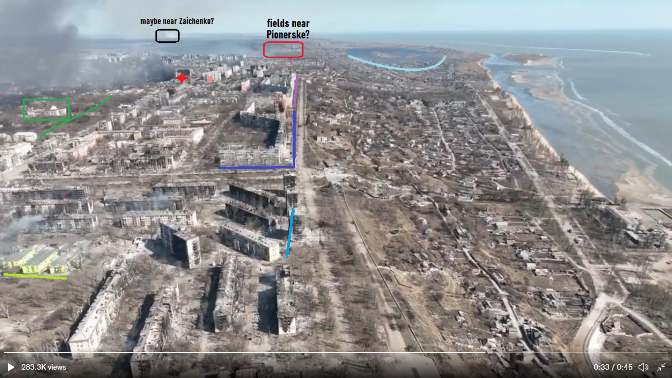

A quick, approximate line of sight extension suggests the distant smoke comes from the fields up to and near Pionerske to the east, and a possible huge fire further out may be near the town of Zaichenko to the northeast. It's not clear if either means much - maybe two fields on fire, presumably from more Russian shelling to the east of Mariupol,
Is this just more Russian brutality in revenge for military setbacks against the steadfast Azov defenders, or what?
Institute for the Study of War's first Mariupol map shows as of March 17 Russian control extended to a line across the middle of this scene, about at the end of that purple line, running left-right just short of the burning tower. A 3/18 map (on Twitter) shows the previous line and a newly assessed advance to include most of the area seen in the new video, marking a curve between administration building seized in the north and Chechen fighters seen in the south. 3/20 advance only noted on 3/21.
On March 22, as that video was filmed, per the ISW map, nothing is assessed as different from the 20th, maybe just from a lack of video and/or analysis. This whole time: a huge yellow unknown of supposedly claimed control since March 10, when an Azov Battalion base was blown up. I've seen as of yesterday the plant's massive grounds were considered more like 60% controlled, 2 weeks later. Below: cropped from their 3/21 map with mine roughly scaled and rotated to match at coastline and marked roads.


I'm not sure how exact that curve of a frontline is to show control, but it makes all these newly-burning structures exactly front-line as of 3/18 and still, as far as the ISW knew. The places burning on the 22nd are all likely perches for snipers and light artillery to slow the Russian-Chechen-DPR advance on the Azovstal plant, where the Azov Battalion remained based, if battered. Or, depending on unclear details, these blocks might also be cleared of resistance and sit well behind Russian lines.
In fact, considering how they helped make this video, Azov Battalion may have just fired those rockets or shells themselves, just to film another "Russian" crime. The further and terrible fire is harder to explain as Russian fire, and same for the distant fires way behind the front line. That looks like random devastation just inflicted on areas Russian forces already occupied for at least 5 days. It gives them no military advantage, just human losses, perhaps, and a mess to clean up, and more rebuilding to do with a strangulated economy. That only makes a sick, possible sense for the Ukrainian side.
No comments:
Post a Comment
Comments welcome. Stay civil and on or near-topic. If you're at all stumped about how to comment, please see this post.